Tombstone: Tough As Helldorado

Late in 1877 adventuresome prospector Ed Schieffelin (1847-1897) left the safety of Fort Huachuca to look for silver in the hills on the east side of the San Pedro River in southeastern Arizona.  Rich ore had been found there 20 years before, but the US Army had only recently tried to take the San Pedro Valley away from militant Apaches.  You’ll not find your fortune out there, the soldiers told Schieffelin, only your tombstone.  Within weeks he found both, facetiously naming one of his silver strikes the Tombstone Mine and the other the Graveyard Mine.  Early the following year Schieffelin returned with his brother Al and partner Richard Gird (1836-1910) to discover the Lucky Cuss and the Tough Nut.

Prospectors, miners and speculators quickly followed and the town of Tombstone, named after the mining district, was surveyed in December 1878.  The territorial governor showed up early in 1879 and invested in a processing mill on the San Pedro River.  In May 1879 the population was estimated at 250.  By the end of that year, Tombstone had become the most famous boomtown in the West, incorporated as a village, with a population just under a thousand, having a newspaper, and a post office for nearly a year already.  Saloons made more headlines but four churches had been organized by 1880.  St. Paul’s Episcopal Church (1882) survives as the oldest Episcopal building in Arizona.  It was built under the leadership of the well-known Reverend Endicott Peabody (1857-1944). 
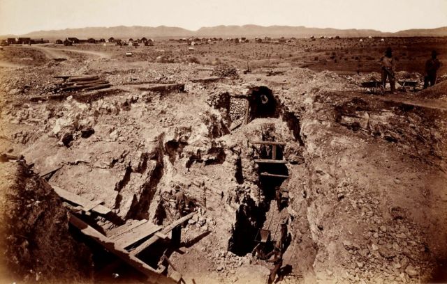
Tough Nut MineThe noted stereograph photographer Carleton Watkins (1829-1916) brought his camera to Tombstone in April 1880, recording this view of the old south shaft ore quarry at the Tough Nut Mine.  The eastern quarter of Tombstone, laid out on Goose Flat, is visible across Toughnut Gulch with the Dragoon Mountains behind.  Most of the town is out of view at left including an already prosperous business district.  There were 110 industrious Chinese residents in Tombstone in 1880, many of them self-reliant entrepreneurs.  (From a glass plate at Yale Beinecke Rare Book and Manuscript Library.) 
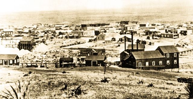
birds-eye-view 1881This birds-eye view of Tombstone in 1881 shows an ore wagon pulled by 15 or 16 mules leaving town for one of the mines or on the way to a mill.  The town had a population of about 4,000 that year with 600 dwellings and two church buildings.  There were 650 men working in the nearby mines.  The Tough Nut hoisting works are in the right foreground.  The firehouse is behind the ore wagons, with the Russ House hotel just to the left of it.  The dark, tall building above the Russ House is the Grand Hotel, and the top of Schieffelin Hall (1881) is visible to the right.  Fire burned a large portion of the business district 22 June 1881 and then again in less than a year.  The Grand Hotel opened in September 1880 and was lost in the 26 May 1882 fire.  Both fires were stopped on the south side of Fremont Street, sparing the original Epitaph newspaper office, Hotel Nobles and Schieffelin Hall.

Residents successfully lobbied the territorial legislature to create Cochise County 1 February 1881 with Tombstone as county seat. The population of Tombstone probably surpassed every other city in Arizona the following year, except maybe Tucson.  Some estimates gave a population figure about double the count made by a territorial census:  5,300 in 1882.  Of course, lots of men were always in town without being counted residents. 
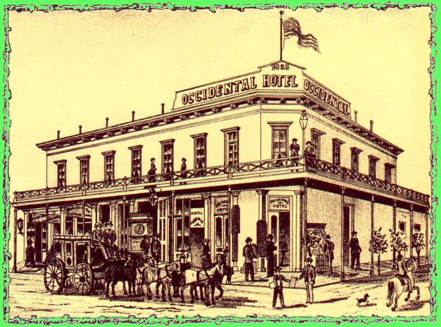
Occidental HotelThe Occidental Hotel was built on the southeast corner of Allen and Fourth Streets.  Joseph Pascholy and Godfrey Tribolet were proprietors.  A hundred guests could be accommodated on the European plan at rates from 50-cents to $2 a day.  This illustration is from Wallace W. Elliott & Co., History of Arizona Territory. . ., (1884) as reproduced in The Image of Arizona by Andrew Wallace (1971).  The building burned sometime in the 1890s.

Access to easy money, by investing in mines, card games and brew, led to violence in an era when men felt the need to arm themselves against attacks by Apaches or stage robbers.  In Pima and Cochise counties friction developed between these “investors” and “cowboys” who made their money from livestock.  But telling the whole truth about the infamous gunfight at the OK Corral is problematic.  Like most storied figures, there is disagreement over whether Wyatt Earp (1848-1929) was a good guy or a bad guy.  The related issue, to what extent Arizona in the 19th Century was a lawless frontier, is central to any understanding of its history.  This perception of a territory of renegade cowboys and Indians, whether founded on facts or not, delayed for more than a decade Arizona’s admittance to the union as a self-governing state.
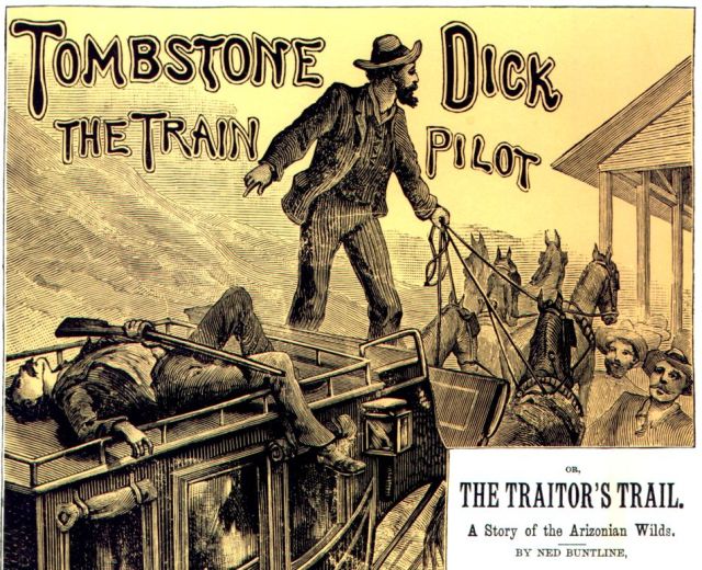
Tombstone Dick 1885Cheap paper and printing in the 19th Century brought a flood of popular dime novels like Wild West Weekly and Buffalo Bill Weekly promoting the myth of a violent confrontation between rugged individuals in the West.  This illustration is from the cover of Beadle’s in 1885.  Movie scripts and then TV repeated the same legends.  As Stewart Udall (1920-2010) pointed out, “Efforts by historians to put western violence in perspective encountered opposition not only from moviemakers but also from members of their own profession who glorified gunfighters as seminal figures of western history.” (p. 186, The Forgotten Founders)  Stories out of three western communities more than any others fed this appetite for violence:  Dodge City, Kansas; Virginia City, Nevada and Tombstone, Arizona. (Illustration from The Image of Arizona by Wallace, 1971)

Wyatt Earp arrived in Tombstone before the end of 1879.  He had recently left Dodge City, Kansas where he had been an off-and-on lawman.  In the spring of 1880 he was a shotgun messenger on Wells Fargo stages.  He was joined in Tombstone by his brothers Virgil, Warren and Morgan and Doc Holliday (1852-1887), a friend from Dodge.  On 28 July 1880 Wyatt was appointed a Pima County Deputy Sheriff.   Virgil (1843-1905) became a Deputy US Marshal and then Tombstone Town Marshal.  Bad blood between the Earps and the Clanton and McLowery families led to a gunfight 26 October 1881 near the OK Corral.  Billy Clanton (1862-1881), Frank McLowery (1848-1881) and Tom McLowery (1853-1881) were killed.  Virgil Earp was wounded but not seriously.  December 28 Virgil was ambushed on the streets of Tombstone and seriously wounded but he recovered, though with lasting debilities.  The following March, Morgan Earp (1851-1882) was assassinated in Tombstone.  The Earps and their friends put together a posse and went after their enemies in the Dragoon Mountains.  In the course of a two-week ride they killed four men.  Then the Earps continued into New Mexico, finally taking refuge in Colorado where the governor refused their extradition.
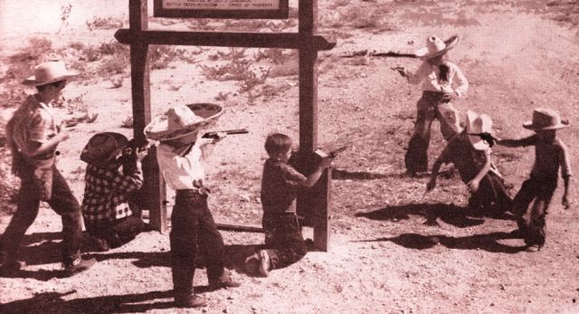
OK Corral kidsThis is what the legendary town meant to several generations of young boys, and not a few men, nourished as they were on a diet of cowboy, shoot-‘em-up literature and movies.  The un-named photographer staged this scene for the Tucson stock photo company Western Ways under the sign marking the OK Corral and it illustrated a September 1951 article on Tombstone in Arizona Highways magazine featuring Douglas D. Martin’s book on the Epitaph newspaper.  The Tombstone Lions club undertook the restoration of the ruins of the OK Corral buildings to promote “the most furious and famous gun battle of all western history,” as the sign in this photo pointed out.  At that time, George J. Geneback of Battle Creek, Michigan was owner of the property.

The Territory of Arizona had been largely populated by southern Democrats from New Mexico and Texas, and yet in 1880 it was led by a Republican Governor appointed by US President Chester Arthur, the sixth Republican President in a row.  The US Justice Department and the Governor prosecuted a war on crime targeting “lawless” Texas cowboys and enlisted the Earps, Republicans who backed a Republican candidate for Pima County Sheriff.  Following the OK Corral shooting, US Marshal for Arizona Crawley P. Dake (1836-1890) telegraphed Washington D.C. to boast how the Earps were helping rid Arizona of the criminal element.  “My deputies at Tombstone have struck an effectual blow to that element, killing three out of five.”

Tombstone seemed to especially deserve its disrepute.  The stage to Tombstone was held up more than once.  Between October 1879 and October 1880 in Pima County there were 25 homicides followed by 15 arrests.  President Arthur suggested Congress repeal the posse comitatis act secured by Democrats following the Civil War in order to limit military occupation of the south.  May 3, 1882 the President proclaimed his power to declare martial law in Arizona if the violence did not abate.  Then, Democrat Grover Cleveland was elected President in November 1884.  At the same time, crime in Tombstone declined—along with the economy.

By 1900 Arizona newspapers had turned abruptly away from sensationalized accounts of gunfights to promote statehood for the now respectable, progressive and peaceful territory.  But Tombstone saw another revenge killing at the OK Corral in 1897.  And the new medium of cinema joined print stories to fill minds with legends of the Wild West.  This would continue, throughout the Twentieth Century, as films and TV shows introduced new generations to lusty, rambunctious Tombstone gunfighters. 
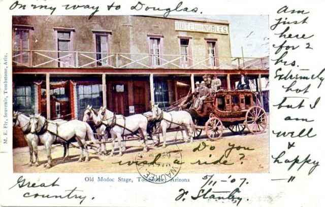
Modoc StageJ. Stanby mailed this souvenir postcard 11 May 1907 from Tombstone and it arrived in Milwaukee three days later.  “On my way to Douglas,” he wrote.  “Great country.  Do you wish a ride?  Am just here for 2 hours. Extremely hot, but I am well and happy.”  The undivided back postcard was likely issued about 1903.  According to postal regulations, until 1907 correspondence had to be written on the front of the card.  Only the address went on the back.  Camillus S. Fly (1849-1901) opened a photographic studio behind his boarding house on Fremont Street in September 1880.  The OK Corral gunfight took place in a vacant lot on the west side of the Fly Gallery.  Camillus’ wife, Mary E. “Mollie” Fly (1847-1925) was also a photographer and ran the Gallery pretty much on her own from 1886 until her retirement in 1912.  For this postcard she colorized one of her husband’s photos from the 1880s.  The stagecoach was built in Tombstone as a large capacity “Modoc” design.  After the railroad came, the old Modoc and Ben Cook coaches may have offered rides for tourists, who experienced a mock holdup along the route.  In December 1925 the Modoc was donated to the Arizona Museum Society at Prescott.  It was driven in rodeo parades until it became a display at the Sharlot Hall Museum.  Tombstone’s Ben Cook stage is at the Arizona Historical Society in Tucson.  By rail in 1907, Tombstone was a short side trip on the way from Benson to Douglas. 

“In the last six years the County has been entirely redeemed from the wild reputation it before bore as a region terrorized by Apaches and equally wild cowboys,” wrote Arizona Territory Commissioner of Immigration John A. Black in his 1890 profile of Cochise County.  “The petulant pop of the pistol is no longer heard, and, while the excitement of the boom days of yore may be missed, while the spice of frontier life may be largely lacking, there remains the solid enterprise and the substantial progress that marks the thrifty community and invites with assurance the immigrant.”  In reality, economic recession and difficulty underground lay ahead.

Water began entering the 500-foot level of the Sulphuret Mine in March 1881.  A year later, ore extraction had to be suspended in the big Contention and Grand Central mines while pumps were installed.  When digging resumed each increase in depth was met by an increase in water.  Financial panic hit Tombstone in 1884, then, fire destroyed the Grand Central pumps in 1886.  The boom was over.  Succeeding years would bring bigger pumps and more water as mining was reduced to a struggle between the falling price of silver and the rising cost of pumping water. 
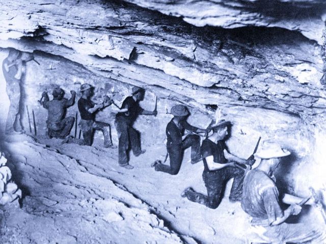
Consolidated Mine drillingFollowing years of recession and closure of the mines Tombstone’s population had sunk to 646 people according to the 1900 census.  Early production figures are not accurate, but it appears that Tombstone mines produced more than $19 million dollars of total value from 1879 through 1886.  Following the loss of pumps, mines still averaged around a half million dollars a year for the next ten years and $4.5 million from 1897-1907.  The Tombstone Consolidated Mines Company was formed in 1901, new pumps installed and mining continued below 1,000 feet.  Magnesium flash powder made possible this photo taken in 1905 on the 500-foot level in the Sulphate Stope of the Consolidated mine.  It shows laborious hand drilling of holes for blasting with the only light coming from candleholders spiked in the wall.
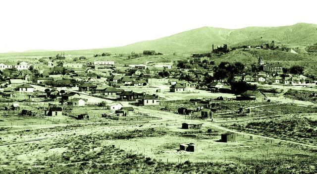
birds-eye-view ca1911When this birds-eye-view looking south was made about 1911 the population had rebounded to more than 1,500.  The photographer set up his camera on the slope of Comstock Hill (a.k.a. “T-Mountain”) on the northwest side of town.  At far left is Schieffelin Hall while at right the tower of the Cochise County Courthouse (1882) is visible below the Toughnut mine.  Railroad tracks are running across the foreground.  The Santa Fe Railway built 1883-1884 from Benson to Fairbank, 12 miles west of Tombstone, and then on to Nogales.  It was not until 1903 that a branch of the El Paso & Southwestern Railway reached Tombstone from Fairbank.  With new pumps and a railway to ship ore to El Paso, Tombstone’s economy recovered 1903-1908.  Then mining became too expensive again.  Most of the pumping machinery failed in 1909 and had to be replaced.  The new pumps were removing 6.8 million gallons a day by the end of 1910, but Tombstone Consolidated Mines had to borrow $6 million dollars to continue operation in 1911.  The numbers didn’t add up.  The pumps were abandoned 19 January 1911 and the mine allowed to flood.  Ore extraction continued on a smaller scale above the water table until the Great Depression nearly turned Tombstone into a ghost town. 
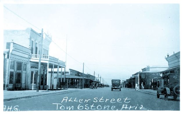
Allen StreetStores were still open on Allen Street in this photo from about 1915.  While many residents hoped for a resurgence of mining, they also promoted tourism.   The intersection pictured is Allen at Fifth Street, looking northwest.  At this time Allen Street was the main route through town and would carry Highway 80 by the late 1920s.  Much later Fremont Street would become Highway 80.  The Crystal Palace Saloon (1882) and the former Oriental Saloon (1880), then Tombstone Drug Store, are on the corners at right.  At left, on the southeast corner of Fifth and Allen, is a hotel in a building built in 1881 for J. Meyer & Brothers Clothing store and the Huachuca Water Company.  Later it was home to the Bucket of Blood Saloon.  The building was remodeled in 1909 to become a hotel.  It housed the Owl Café (next door; Paul Hood, manager) and Tourist Hotel (Joe Hood, manager) beginning in 1928 but burned in 1942.  It is now the site of Longhorn Restaurant.

In 1928 William M. “Billy” Breakenridge (1846-1931) published his memoir entitled Helldorado, The True Story of Tombstone.  The following year “Helldorado Days,” a four-day celebration of gunfights and holdups, prospectors and madams was held in October.  But the Great Depression would put a damper on festivities, especially since Tombstone lost the county seat in 1929, leaving its courthouse vacant by 1931.
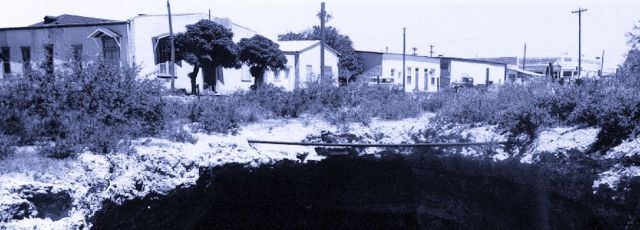
Million Dollar StopeBy 1930 the millions of dollars dug out of the earth had left town long ago.  Mining collapsed and Tombstone suffered a severe decline during the depression years.  The dark emptiness lurking at the bottom of this photo of buildings along Fifth Street is called the “Million Dollar Stope,” part of an underground excavation that caved in under the weight of a horse and wagon in 1907, exposing the hollowness underlying Tombstone and its economy.  Unlike the mine, both horse and driver survived the fall.  Nellie Cashman’s Russ House is behind the trees at left and the Crystal Palace Saloon is visible at right.  The illustration is cropped from a 1930s postcard by Burton Frasher (1888-1955) of Pomona, California. 
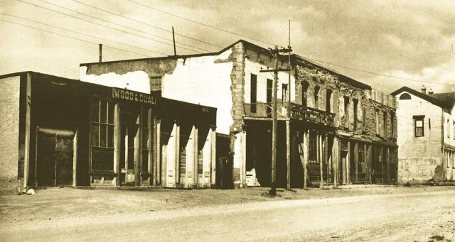
Gird BlockMiners Exchange Hall, also known as the Gird Block (1880) on the northwest corner of Fourth and Fremont Streets once accommodated sessions of the First Judicial District court.  Later it became the Hotel Nobles as pictured above behind the Modoc Stage.  The corner of Schieffelin Hall is visible at far right.  The white-plastered building is the original home of the Tombstone Epitaph.  Editor John P. Clum (1851-1932) and two partners printed the first issue dated 1 May 1880.  Clum was a Republican, elected Mayor in 1881 and then defeated for re-election the following year after supporting the Earps.  May 1, 1882 he sold the Epitaph and left town.  The “Wood & Coal” building once housed a public library.  The entire row of buildings was demolished in the 1950s and is now a vacant lot.  Long before that, the Epitaph relocated to a building just north of the Crystal Palace Saloon on Fifth Street, with the so-called “hangman tree” out front. 
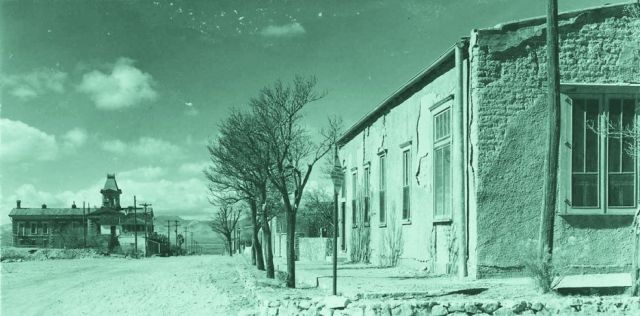
Toughnut & FifthA rough and tumble mining camp had to have at least one angel and Tombstone had Nellie Cashman (1845-1925).  She took in boarders at the Russ House on the northwest corner of Toughnut and Fifth Streets (at right).  She saw that the hungry were fed and the sick nursed.  And she boldly tore down bleachers erected for a public hanging in order to put a damper on the spectacle.  The million-dollar Cochise County Courthouse (1882) is two blocks farther down Toughnut Street (at left).  Voters moved the county seat to Bisbee in 1929.  The old courthouse became one of the first Arizona State Parks in 1959.  In front of the courthouse is an old hospital building (with covered sidewalk).  Like most mining towns, Tombstone always had a hospital until recent times.  An earlier hospital building was located at the west end of Allen Street.  This view of Toughnut Street looking northwest is cropped from a Burton Frasher postcard issued about 1940.
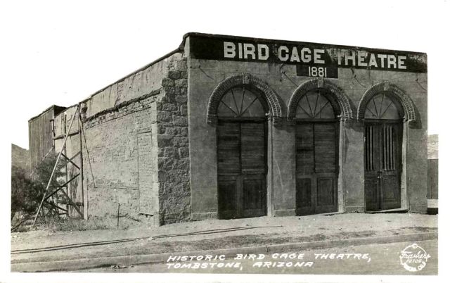
Bird Cage TheatreSoon after opening Christmas Day 1881, The Elite Theatre offered men everything that was wild and wicked, and typical of mining boom towns in the West.  It was a theater and saloon, with 24-hour drinking and gambling, plus shady ladies for hire.  At some point the name was changed to the Bird Cage.  It closed in 1925 and by the early thirties when Burton Frasher took this photograph had been boarded up for years.  By 1937, visitors could tour the musty interior filled with curiosities.  A tiny addition replaced the shoring holding up the wall at left to offer food and drink.
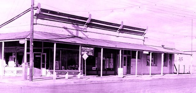
Tombstone Drug StoreThe Oriental Saloon opened 22 July 1881 on the northeast corner of Fifth and Allen, across the street from the Eagle Brewery (later Crystal Palace).  Wyatt Earp purchased an interest in the saloon’s gambling tables, some of the most lucrative in town.  Where money and liquor mixed, violence followed and several notorious shootings occurred just outside the Oriental.  It burned in the 1881 fire but was quickly rebuilt and suffered only minor damage during the fire of 1882.  Eventually, the law caught up with the place.  After the state legislature enacted prohibition of alcohol in 1914, Tombstone Drug Store moved into the building.  Drug store soda fountains were an early alternative to booze.  In the 1930s, when Burton Frasher recorded the building in this view, it was advertising cigars, cigarettes, Coca-Cola and ice cream.  The post office was housed in the corner of the building at right and the Chamber of Commerce was inside the next building to the right.
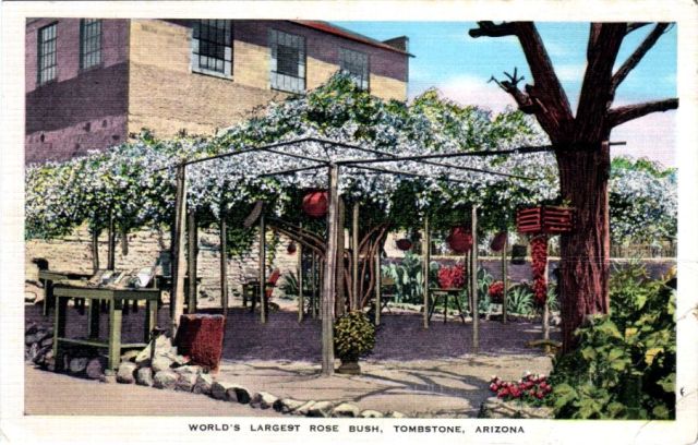
rose bushVizina Mining Company built the first adobe building in town in 1885, a boarding house for employees on Toughnut Street across from the later site of the railroad depot.  The same year a rose bush from Scotland was planted in the backyard by Mary Gee.  Later, the establishment became the Cochise House Hotel, then the Arcade Hotel from 1909 to 1936.  By the 1930s, when this postcard was created, the rose had grown to shade the entire patio out back and was a popular site for tourists.  The hotel was renamed Rose Tree Inn.  By 1973 the white rambler Lady Banksia variety had spread to cover more than 7,000 square feet with a trunk approaching 60-inches in girth.  This past April it bloomed for the 127th time.  In this scene the Inn is out of view at right.  The two-story building behind the patio is now home to Arlene’s gallery on Allen Street.

The Cochise County Hospital opened in Tombstone in the 1880s but moved to Douglas about 1909.  In 1945 Dr. Peter Paul Zinn of Bisbee and Father Aloysius “Roger” Aull (ca1895-1948) of New Mexico opened a lung disease clinic known as the Medical Center in an 1881 bank building.  Drawing hundreds of invalids from far away, it was soon renamed Tombstone General Hospital.  But the treatment did not prove effective and the institution was short lived.  The town “too tough to die” benefited more from a number of movies and two long-running TV series:  Tombstone Territory (1957-1960) and The Life and Legend of Wyatt Earp (1955–1961).
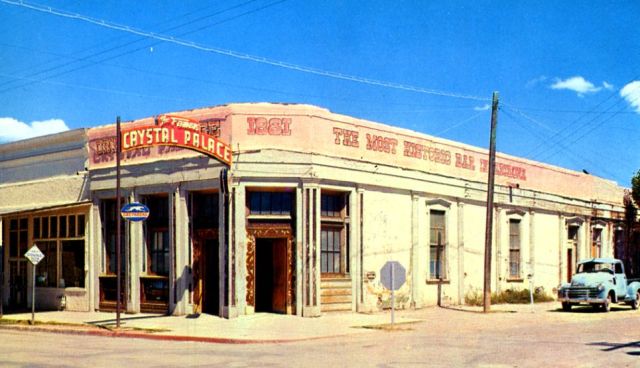
Crystal Palace SaloonGolden Eagle Brewery (1879-1881) originally occupied the site of the Crystal Palace Saloon.  The brewery burned twice then was rebuilt in 1882 as the two-story Crystal Palace.  The second floor was removed during a 1904 remodel and then the front arcade over the sidewalk was removed in the 1930s.  This view in the 1950s is from a postcard issued by Bob Petley.  The next building at left used to be A. Cristini’s grocery 1920s-1940s.  The Tombstone Epitaph building is behind the pickup at right.  The Crystal Palace has now been restored to two stories with a covered sidewalk once again.
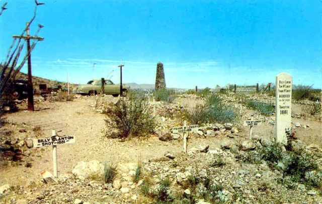
Boot HillThe term “Boot Hill,” for the final resting place of those who “died with their boots on,” probably originated in Dodge City, Kansas.  Tombstone’s Boot Hill, used 1879-1884, fell into neglect after it was replaced by a cemetery just beyond the west end of Allen Street.  But in an effort to make Boot Hill a tourist destination, ten years of cleanup and restoration 1923-1933 culminated in a billboard along Highway 80.  At first the cemetery was thought to be a potters field for outlaws, but then the first non-villain grave was identified in 1937.  Local boosters decided a respected businessman, Quong Kee (1851-1938), owner of the popular Can Can Restaurant on the corner of Fourth and Allen, should be given a widely publicized burial at Boot Hill in 1938.  The event marked a turning point, away from obscurity and shame for the graveyard, making it one of the most visited sights in town.  A custodian was hired in 1945 and he opened a souvenir stand at the entrance.  This Kodachrome postcard was issued in 1951 by Curteich of Chicago and distributed by Lollesgard Specialty Company of Tucson and Phoenix.  The two iron crosses (at left and by the car) are actually street lampposts moved from downtown.  Roy Fourr Post No. 24 of the American Legion placed the stone obelisk in 1937 in memory of unidentified veterans, pioneers and settlers.  The graves of OK Corral victims are prominent in the foreground. 
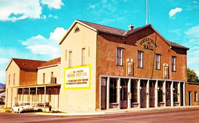
Schieffelin HallIn 1881, Al Scheiffelin (1849-1885) built one of the largest adobe buildings in the entire country as an opera house on the northeast corner of Fourth and Fremont Streets. Every sizable town in Arizona Territory had its “opera house” where all sorts of live shows were performed by traveling companies.  Scheiffelin Hall also accommodated meetings of the Ancient Order of United Workmen and the Masons.  The Dick Parrish photo was published about 1966 as a Plastichrome postcard by Petley Studios of Phoenix.  At that time visitors could see the “Amazing Tombstone Historama” (yellow-bordered sign) in the auditorium, an animated diorama illustrating the town’s history with narration by Vincent Price.
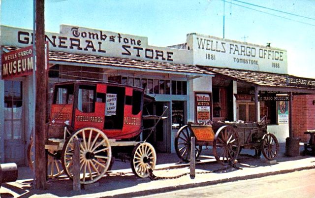
General Store & Wells Fargo OfficeWells Fargo established its first office in Tombstone in May 1880 near Third and Fremont Streets.  The building pictured here is located on Allen Street between Fifth and Sixth.  Tombstone General Store had “the old-time fixtures, selling old-time candies and other confections.”  The photo by Dick Parrish was published by Petley Studios of Phoenix and printed as a postcard by Dexter Press, West Nyack, New York.  It was postmarked in 1969.

In recent years Tombstone has continued to ride a series of booms that soon fade. The last train left town 13 August 1960 and the rails were removed soon after.  The former depot became the town’s public library in 1961.  Highway 80 has lost most of its traffic to Interstate 10.  Two recent attempts to mine at Tombstone ended in bankruptcy, in 1985 (Tombstone Exploration Inc.) and 1990 (Cowichan Resources).  Nevertheless, release of the movies Tombstone (1993) and Wyatt Earp (1994) brought a new influx of visitors and now the downtown resembles a movie lot theme park.  Old buildings have been restored to their 1880s grandeur with bright colors and lots of polish.

See:

Leo M. Banks, “This Shooting at the O.K. Corral Failed to Make the History Books,” Arizona Highways, Oct. 1998, pp. 22-25

John A. Black, Arizona, The Land of Sunshine and Silver, Health and Prosperity, The Place For Ideal Homes, (1890)

T. Roger Blythe, A Pictorial Souvenir and Historical Sketch of Tombstone Arizona, (1946)

William M. Breakenridge, Helldorado:  The True Story of Tombstone, (1928)

Kevin Britz, “‘Boot Hill Burlesque’:  The Frontier Cemetery as Tourist Attraction in Tombtone, Arizona and Dodge City, Kansas,” The Journal of Arizona History, Autumn 2003

B. S. Butler, et al., Geology and Ore Deposits of the Tombstone District, Arizona, U. Of A., Arizona Bureau of Mines Bulletin 143, (1938)

Eric L. Clements, After the Boom In Tombstone and Jerome. . ., (2003)

Stephen Cresswell, Mormons & Cowboys, Moonshiners & Klansmen:  Federal Law Enforcement in the South & West, 1870-1893, (1991)

Jane Eppinga, Arizona Sheriffs, (2006)

Jane Eppinga, Around Tombstone, (2009)

Jane Eppinga, Tombstone, (2010)

Douglas D. Martin, Tombstone’s Epitaph, (1951)

Douglas D. Martin, “Tombstone’s Epitaph,” Arizona Highways, Sept. 1951, pp. 2-9

Joseph Miller, “Tombstone, ‘The Town Too Tough To Die,’” Arizona Highways, May 1945, pp. 32-37

Sherry Monahan, Taste of Tombstone, (2008)

Sherry Monahan, Tombstone’s Treasure, (2007)

Joseph P. Schwieterman, When the Railroad Leaves Town, (2004)

James E. & Barbara H. Sherman, Ghost Towns of Arizona, (1969)

Stewart L. Udall, The Forgotten Founders, (2002)

W. John “Jack” Way, The Tombstone Story, (1965)

Posted in Tombstone | 4 Comments

Arizona Skyways Were Sunny & Blue

According to Border Air Museum in Douglas, the first airplane to fly in Arizona was a glider built in 1908 by Douglas Aeronautical Club members.  They added an engine the following year and in 1913 the by then obsolete design bombed Mexico for General Pershing’s troops.  The 1908 Territorial Fair at Phoenix featured a balloon ascension and a dirigible appeared at the 1909 fair.  Also in 1909, a glider was exhibited and towed briefly aloft.  Powered aircraft showed up in Phoenix for only the second Aviation Meet in the whole country, 10-12 February 1910 at the fairgrounds.  Two pilots in Curtiss biplanes made several flights, once carrying a passenger and twice racing automobiles.  One of the planes then went on to Tucson later that month.  Katherine Stinson (1891-1977), the first woman to fly airmail in the US and the first pilot to fly at night, delivered airmail to Tucson in November 1915.  That was another first for Arizona.

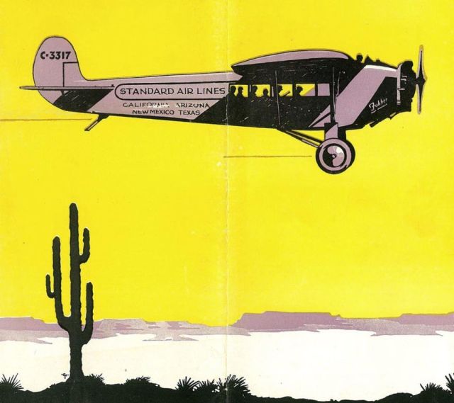
Standard Air Lines Fokker UniversalAero Corporation of California established Standard Air Lines to fly the “Fair Weather Route” from Los Angeles to Phoenix, Tucson, Douglas and El Paso, beginning 28 November 1927.  It was Arizona’s first scheduled airline service.  Standard was sold to Western Air Express in March 1930.  By complicated business deals American Airlines would get Standard’s southern Arizona route while WAE would become TWA with the transcontinental route across northern Arizona.  Fokker Universal registration number C-3317, construction number 426 was manufactured in October 1927 by Atlantic Aircraft Corporation, Teterboro Airport, Hasbrouck Heights, New Jersey and fitted with a Wright J-5 engine.  The pilot flew in an open cockpit at the leading edge of the wing.  An enclosed cabin accommodated 4-6 passengers.  Aero Corporation of California purchased the machine 23 November 1927 and featured it in Standard Air Lines advertising, including the 1929 timetable cover shown here.  It flew very well for Standard from December 1927 through December 1929.  By 1932 the aircraft had been repossessed by the bank, after passing through a number of private owners and establishing a 40-hour endurance record September 28-30, 1932 with aerial refueling.  The history of the plane ends following a minor crash in Los Angeles 17 November 1933.  

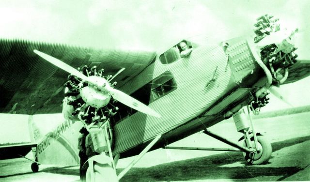
Scenic Airways trimotorJ. Parker Van Zandt (1894-1990) established Scenic Airways in 1927 to fly tourists over the Grand Canyon.  A single-engine Stinson SM-1 Detroiter and a Ford Trimotor were based at Red Butte airport 13 miles south of the south rim of the canyon.  This photo from the University of Wyoming collection shows boarding of the Ford 4-AT-B Trimotor NC5493, probably at Red Butte.  The company name changed to Grand Canyon Airlines in 1930 and remains in business as the world’s oldest air tour service in continuous operation.  An air tour service with almost the same name, Scenic Airlines, started up in Las Vegas in 1967.  Through mergers Scenic Airlines operated scheduled passenger service for a time but returned to tours in 2006 and was sold to Grand Canyon Airlines in 2007.  Scenic Airlines was completely absorbed by Grand Canyon Airlines in 2009. 

Phoenix opened a municipal airport in 1926 on Christy Road (McDowell west of Six Points, near 59th Avenue).  Scenic Airways chose a location across town to build 1928-1929 Sky Harbor Field but then pulled out and sold the new airport in 1930 to a firm called Acme.  American Airlines began scheduled flights at Sky Harbor the same year.  Also in 1930, Desert Airways was operating from Phoenix South Central Airport (gone now, site of Rio Salado Park).  In 1935, the City of Phoenix purchased Sky Harbor, abandoning its Christy facility.  It was a chaotic time during the early development of commercial aviation, just as the economy collapsed into the Great Depression.  Still, within a few years airline travel would emerge on a firm footing only to be disrupted again, this time by world war.  Throughout the 1930s American Airlines continued to fly the old Standard Air Lines route, providing flights from Los Angeles and Texas into Phoenix Sky Harbor, Tucson and Douglas.  In 1938, TWA connected Phoenix with San Francisco.

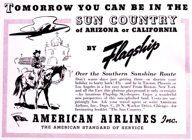
AmerAirlines Arizona adFlying upscale vacationers to the Sun Country became a viable alternative to train, bus and auto transportation with the introduction of twin-engine Douglas DC-3 aircraft, the first airliner to consistently earn a profit.  In 1929 Aviation Corporation began acquiring and consolidating a number of smaller carriers.  These subsidiaries were combined in 1930 to form American Airways Inc., which became American Airlines in 1934.  As this ad from around 1940 shows, American Airlines DC-3 Flagship Skysleepers connected the east and west coasts with Tucson and Phoenix, providing the “American Standard of Service.”

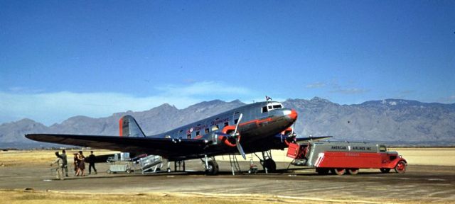
Flagship Texas at TucsonDuring a visit to Tucson in February 1940, Charles W. Cushman (1896-1972) snapped this photo of American Airlines Flagship Skysleeper Texas refueling at Davis-Monthan Aviation Field before it became a military base.  It sure illustrates the clear flying weather in an Arizona winter, conditions which attracted the industry.  And the warm winters brought visitors to the many guest ranches and resorts in southern Arizona.  Many of these guests could afford to fly.  Flagship Texas, NC14988 c/n 1494, was the first of 10 DST-114 models for American Airlines ordered in 1935.  Douglas Sleeper Transports began flying through night skies 18 September 1936.  Small windows for the upper berths make the DST easy to spot.  Repaired after two minor accidents in 1938, Flagship Texas was sold to TWA in May 1942.  In July 1942 the Army Air Force converted NC14988 into a C-49E troop transport (USAAF 42-43619) and on October 15, 1942 it crashed and burned in Missouri, killing the one pilot on board.  (Photo from Indiana University Archives, Cushman collection.)

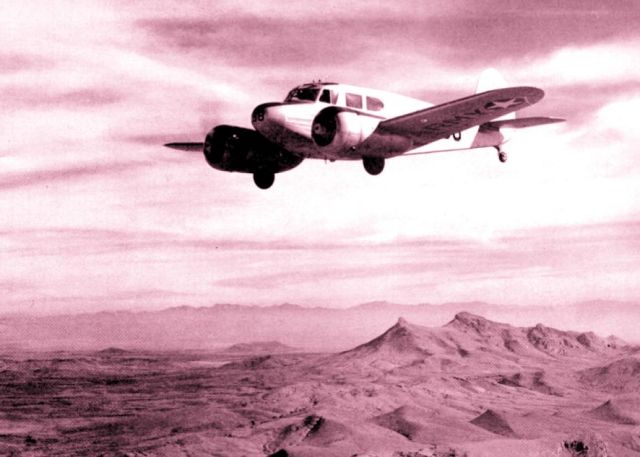
Douglas AT-17World War II brought a number of air bases to Arizona, giving the state an important role in pilot training that has endured.  At Douglas Army Airfield, about 10 miles north of Douglas, Arizona, pilots earned their twin-engine rating during World War II in B-25 bombers and the AT-17, pictured here from a 1943 Douglas cadet yearbook.  Fabric covering over wood construction and a tubular steel frame earned the Cessna AT-17 Bobcat the nickname “Bamboo Bomber.”  Based on the civilian T-50 that first flew in 1939, the cheap construction allowed the military to purchase 4,600 Bobcats during the war.  Following the war, surplus Bobcats were acquired by general aviation owners.  It was known as an easy plane to fly.  Douglas Army Airfield was constructed 1941-1943.  It was one of only four Army Air Fields in the US to include both African-American soldiers and WACs, and was the second air field to receive black WACs.  It became Bisbee-Douglas International Airport in 1949, supplementing Douglas Municipal Airport, established in 1928 closer to town.

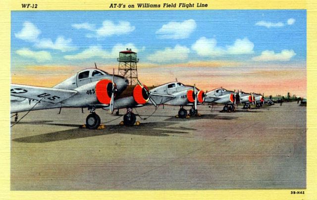
Williams Field flight lineWilliams Army Airfield was built southeast of Mesa in 1941.  Named for 1st Lt. Charles Linton Williams (1898–1927), the facility trained pilots, gunners and radar observers.  The planes shown are Curtiss-Wright AT-9 “Jeeps,” twin-engine trainers for bomber pilots.  Built 1941-1943, the compact little aircraft were designed to be difficult to fly in order to challenge pilots who would go on to more powerful machines under harrowing combat conditions.  Williams Field airmen also trained in Beech AT-10s, Cessna AT-17s, Lockheed P-38s and North American AT-6s.  There were nearly 200 AT-9s at Williams when this Genuine Curteich-Chicago, C.T. Art-Colortone postcard was printed in 1943.  The card was produced for distribution by Lollesgard Specialty Co. of Tucson.  After the war, Williams Field continued to train pilots and gunners, adding the new jets to the flight line.  In 1948 the airfield became Williams Air Force Base for advanced single-engine training.  The base closed 30 September 1993 but transitioned to commercial aviation as Phoenix-Mesa Gateway Airport.  

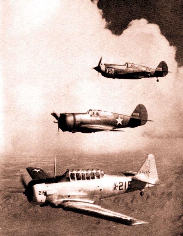
Luke Field en echelonLitchfield Park Air Base was constructed 15 miles west of Phoenix in 1941 and renamed that same year for Medal of Honor recipient 2nd Lt. Frank Luke, Jr. (1897–1918).  Advanced flight training in the AT-6 began immediately.  It became the largest fighter training base of World War II.  In this illustration from a 1943 squadron yearbook, three training aircraft from Luke Field fly en echelon over the Arizona desert.  From top to bottom, the planes are a Curtiss P-40 Warhawk, the older Curtiss P-36 Hawk and a North American Aviation AT-6 Texan.  Though its performance fell short of newer designs, the P-40 saw extensive combat operation during World War II as a low-level air superiority platform.  The P-36 was obsolete for combat deployment but useful for training while the AT-6 became the most popular and enduring advanced single-engine trainer.  With the end of hostilities, Luke Field was deactivated 30 November 1946 but then, after the outbreak of the Korean War, reactivated 1 February 1951 as Luke Air Force Base.  The facility has endured to become the largest fighter training base in the world, transitioning recently from emphasis on the F-16 Fighting Falcon to the F-35 Lightning II.  In addition to Douglas, Williams and Luke, there were Army airfields during the Second World War at Tucson, Glendale, Goodyear, Mesa, Prescott, Kingman, Winslow and Yuma, supported by dozens of auxiliary landing strips. 

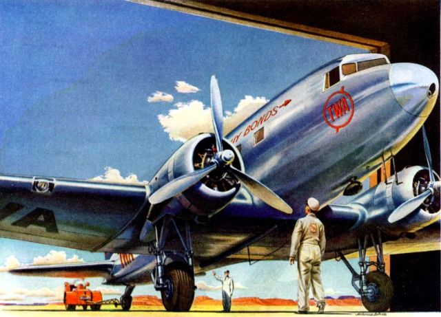
Winslow TWA DC-3With US entry into World War II, commercial airline service became vital to the war effort but suffered from withdrawal of some of the newest and largest planes for military operation.  Airlines turned over about half their planes to the military and new DC-4 and Lockheed Constellation models would not be available for civilian use until after the war.  But repair and maintenance of remaining aircraft like the DC-3 pictured at Winslow in this TWA advertisement continued with renewed motivation.  “Buy Liberty Bonds,” urges the slogan painted within the TWA arrow logo.  (See the Winslow history posted 9/12/11 for another view of the TWA hangar.)

Following World War II Arizona experienced a population explosion driving the rapid development of all forms of transportation.  Both private and commercial aviation benefited from a large supply of cheap war-surplus planes.  And the cost of airline travel fell enough to increase the number of passengers.  As a result, a number of local airlines were born in the state, while the national carriers expanded flight schedules through Phoenix and Tucson.

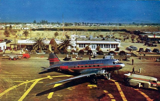
PHX Sky Harbor 1940sThis postcard from about 1947 shows the oldest Phoenix Sky Harbor terminal that used to be located on the north side of the runway that became the civil aviation runway in the 1960s and is now the site of Runway 8-26.  The SPRR tracks are running in the line of low trees behind the terminal, with Washington Street far in the distance.  The houses at upper left are on Madison and Jackson.  By the late 1930s, Sky Harbor offered fly-in weddings at the outdoor chapel visible between the two palm trees.  There was a control tower attached to a hanger out of view at right.  Intermountain Tourist Supply of Salt Lake City distributed the Kodachrome postcard by Mike Roberts.  A caption on the back says: “Sky Haven Airport [sic.] and Sky Chef Café. . . .  Scheduled flights by swift modern airliners connect the Phoenix Sky Haven Airport with all parts of the world.”  Sky Chef Cafe, was operated by Skychefs Inc., a subsidiary of American Airlines.  Later, Sky Harbor offered a Sky Chief dining room.

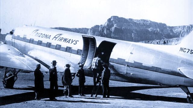
Arizona Airways DC-3H. O. Rocky Nelson (1905-1951) formed Arizona Airways 8 September 1942 in Safford.  Scenic tours of northern Arizona began in March 1946, then, scheduled service across the state with three Douglas DC-3s.  The company got an airmail contract in 1948 but was unable to sustain financial viability and merged with Monarch Airlines in 1949 and then Challenger Airlines to form Frontier Airlines in 1950.  The Douglas DC-3C, c/n 6053, registered as NC75028, is shown boarding, probably at Clifton.  The passengers are entering through the forward half of the double cargo door.  The aircraft was built in 1942 for the US Army as a C-47 cargo plane.  Acquired as surplus after the war, it flew with Arizona Airways 1946-1950 then as Frontier Sunliner Teton.  Southeast Airlines of Miami, Florida exported the aircraft in 1967 to Surinam where it flew under KLM Aerocarto registration as PZ-TLC.  Flying as TG-AXA with Aviateca Guatamala beginning in March 1979, it finally ran off the runway and nosed over after a tire blew while landing at Carmelita.  There is no record of it being returned to service.  

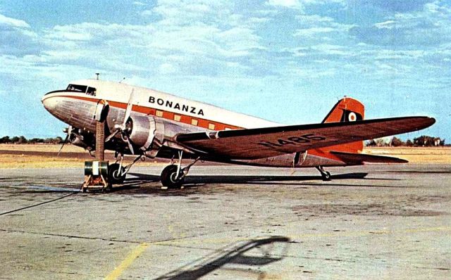
Bonanza DC-3Bonanza Air Lines was established in Las Vegas in 1945 and began flying a Reno-Las Vegas-Phoenix route in 1949.  Flights to Los Angeles were added in July 1952 and ten DC-3 aircraft like the one pictured were flying Bonanza colors by 1957.  In 1944, Florence Murphy (1911-2006) of Las Vegas was the first woman in Nevada to earn a commercial pilot’s license.  She joined Bonanza Air Lines in 1946 to fly DC-3s and became the only female airline vice president in the country.  She left the airline in 1958 to go into real estate.  In 1958 and 1959 Bonanza expanded flights to Los Angeles LAX and began replacing DC-3s with Fairchild F-27s. This Dick Hurley photo published as a postcard by Aviation World Inc. of Bethel, Connecticut shows the new white, orange and black livery on N485 c/n 4848.  I think the drum and hose contraption going to the airmail door is a portable air conditioner.  The location is probably sweltering Phoenix.  Before the color change the DC-3A had been numbered N15564.  After first flying for the Army in 1942 as a C-53-DO the aircraft was with Bonanza 1957-1963.  It then went to Edde Airlines and crashed into a hill in a snowstorm 27 November 1965 about five minutes after takeoff from Salt Lake City International.  All four crew and nine passengers were killed.

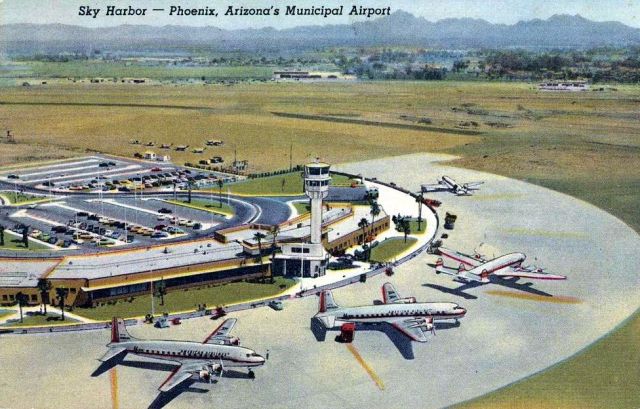
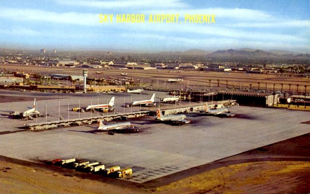
PHX Sky Harbor apronRunways at Sky Harbor were realigned and a completely new, million-dollar terminal opened in 1952, located about a half-mile south of the old terminal.  It featured a 50,000 square-foot terminal building, a 107-foot control tower on top of an unusual tubular support, an 850-car parking lot and 10-plane parking apron providing 44 flights a day.  There were three runways now, each over a mile long.  This Curteich-Chicago, C. T. Art-Colortone postcard issued in 1953 shows two American Airlines DC-6 Mainliners in the foreground and a TWA Constellation at right.  The smallest airliner is a DC-3, a type flown into Sky Harbor at the time by both Bonanza and Frontier Airlines.  A number of private planes are tied down northeast of the parking lot.  The former terminal, out of view at left, had become an industrial park.  Skyriders Hotel, later Sheraton Sky Riders, “the nation’s first airport hotel,” opened on the west side of the terminal in 1954.

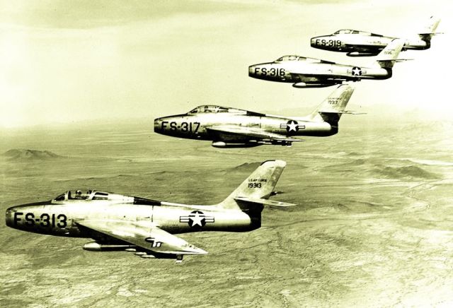
Luke AFB F-84F ThunderstreaksThe Republic F-84 Thunderjet was one of the earliest turbojet designs.  It first flew in 1946 and entered service in 1947 but had to overcome a number of airframe and engine problems before it could be considered operational, in 1949—just in time for missions in Korea.  Republic began work that same year on a swept-wing version designated F-84F Thunderstreak, but the final result was really a very different design that first flew in 1952.  Again, bugs had to be worked out and the Thunderstreak was not considered operational until 1954.  In January of that year, F-84Fs began arriving at Luke AFB.  This flight of armed Thunderstreaks cruises over the Goldwater Gunnery Range west of Ajo in 1956.

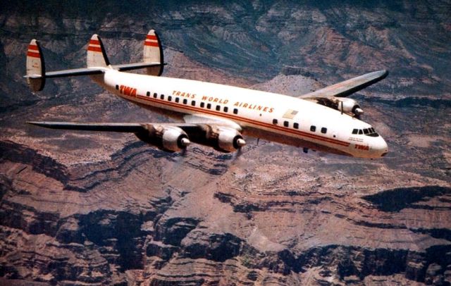
TWA Super ConnieTranscontinental Air Transport (TAT) was founded in 1928 and began 48-hour coast-to-coast service in July 1929 with Ford Trimotors.  Passengers flew in the clouds by day and slept on a speeding train at night.  Planes stopped at Winslow and Port Kingman in Arizona.  (See Kingman post 6/5/2010 and Winslow 9/12/2011.)  TAT merged with Western Air Express in 1930 to form Transcontinental & Western Air, which became TWA.  Largely through part ownership by Howard Hughes (1905-1976), TWA invested heavily in the Lockheed Constellation for transcontinental and international flights beginning in 1946.  The first TWA constellation arrived at Sky Harbor late in December 1946.  In 1953, TWA Constellations began the first Los Angeles to New York non-stop service, making the trip in eight hours, with a view of the Grand Canyon along the way as shown on this postcard from the time.

Many other airlines achieved some degree of success or failure in Arizona over the years.  Gilpin Air Lines (1931-1934) built its own airport in north Tucson.  America West Airlines (1983-2005) maintained a Phoenix hub and corporate headquarters in Tempe, now headquarters for its descendent, US Airways.  Frontier (1950-1987) brought air travel to several smaller cities in Arizona, followed by Apache Airlines (1957-1970), Sun Aire Lines (1968-1984), Cochise (1971-ca.1982), Skywest (1972- ), Copper State Airlines (1980-1982), Sun West (ca.1980-1985) and Mesa Airlines (1980- ).  New corporations have recently resurrected two old business names:  Arizona Airways (1993-1998) and Frontier (1994- ).  The Airline Deregulation Act of 1978 continued government subsidies for airline service, a practice dating to the airmail contracts of the 1920s, but removed caps on pricing.  That law, and recent swings in commodity prices brought volatility to the industry. 

General aviation, the private companion to the commercial aviation industry has always been strong in Arizona.  Deer Valley Airport, a Phoenix municipal facility, is now the country’s busiest general aviation harbor.  Long ago, Arizona’s mild weather encouraged innovation in the air.  Lake Havasu City began as a fly-in recreational site without automobile access.  Then, even after highways were extended, developers created their own airline to drop in prospective homebuyers for tours of lakefront lots.  (See the 6/14/2010, Lake Havasu City posting on this blog.)  Stellar Airpark, just north of Loop 202 at McClintock in Chandler, was created in the 1970s as an aerospace age subdivision where commuters taxied light planes right to their homes.  It has been expanded and maintained in recent years. 

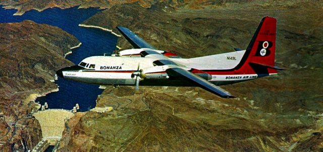
Bonanza F-27 Silver DartThe outlook remained sunny for Bonanza when this Silver Dart was photographed over Hoover Dam, probably in the 1960s.  The first of 11 Fokker F-27 twin turbo-props, or “prop-jets,” manufactured in the USA by Fairchild, arrived in 1959 and after November 1960 Bonanza advertised itself as the “first all jet-powered airline in America.”  The airline’s first fatal crash came in 1964, but it continued to grow its business nevertheless.  Fairchild F-27A, N149L first flew in 1959 and joined the Bonanza fleet in September of that year.  On 8 December 1965 the aircraft suffered substantial damage when the gear retracted during the landing roll at Yuma but it was repaired and returned to service.  AirWest sold the plane in 1980 and it flew for Aeronor Chile under the registration CC-CJE.  The left engine quit and the airliner stalled on final approach to La Serena 9 December 1982 and crashed and burned short of the runway, killing all 46 occupants.  According to one source, it remains the worst loss involving a Fairchild F-27 and the second worst accident ever in Chile.

PHX Terminal TwoAmerican Airlines inaugurated daily jet service to Phoenix in September 1960 and TWA followed in January 1961.  Terminal 2, built at a cost of about $2.7 million, opened in April 1962.  At the time, 13 Arizona airports were served by eight airlines.  American Airlines, Apache Airlines, Bonanza, Continental, Frontier, Trans-World and Western Airlines variously offered service at Clifton, Flagstaff, Fort Huachuca, Grand Canyon, Kingman, Page, Prescott, Phoenix, Safford, Sierra Vista, Tucson, Winslow and Yuma.  And Aeronaves de Mexico connected Tucson with Mexico City.  Bob Petley of Phoenix published the Mike Roberts photo as a postcard in 1962 or 1963, looking northwest toward the skyscrapers on North Central.  Three American Airlines planes are parked on the east side of the gate concourse, including a prop liner.  A far left is a Western Airlines jetliner, followed to the right by two TWA jets and a TWA constellation.  In those days you could walk outside on the roof above the gates and watch planes come and go.  Terminal One with its control tower was demolished in the 1990s.  Terminal Three opened in 1979 and was enlarged in 1984 and Terminal Four opened in 1990.  The Terminal One control tower survives as a feature of the FBO terminal operated by Cutter Aviation on the south side of Sky Harbor, on Old Tower Road.

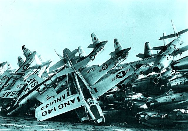
Davis-Monthan F-84 scrapheapLike so many toys tossed in a heap, once fearsome, now obsolete, straight-wing F-84 jets await the melting pot at Davis-Monthan AFB, disposal yard.  Davis-Monthan Air Force Base was originally constructed in 1927 as Tucson’s second municipal airport, used only occasionally by military aircraft.  Standard Air Lines and then American Airlines planes stopped there daily.  But in 1941 it was rebuilt as an Army Air Force field and it remains a military installation.  A Military Aircraft Storage & Disposition Center was established there in 1945 to mothball surplus aircraft for reuse, salvage parts and scrap obsolete planes.  It’s now called the Aircraft Maintenance and Regeneration Center (AMARC).  The photo is from a postcard issued in France.

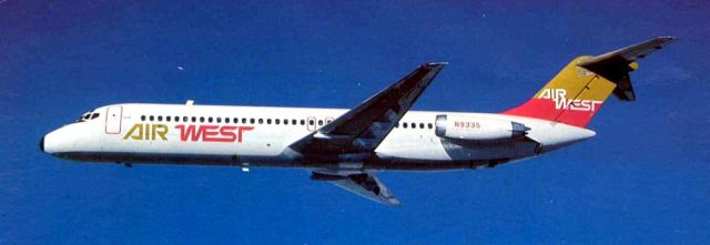
Air West DC-9-31The first Bonanza DC-9 FanJet flight, in 1966, came the same year the airline moved its headquarters and maintenance facility to Phoenix Sky Harbor.  The following year Bonanza merged with West Coast and Pacific Airlines to become Air West Inc.  Howard Hughes purchased Air West in 1970.  Hughes AirWest was sold to Republic Airlines in 1980, which then merged into Northwest.  Douglas DC-9-31, registered as N9335, c/n 47337, was manufactured in October 1968 and delivered to Air West the following month.  It flew scheduled service for more than 30 years for Hughes, Republic and Northwest, accumulating 95,872 hours in the air.  In 2007, the aircraft finally ending up in storage at Marana-Pinal Air Park MZJ, in the desert north of Tucson, along with a number of its sister ships.

Several previous postings on this blog include aviation history:

1956 crash over Grand Canyon posted 10/30/09 in Arizona Apocalypto.

Douglas Army Air Field & airport posted 1/13/10.

Kingman Army Air Field & airport posted 6/5/10.

Lake Havasu City aviation posted 6/14/10.

Phoenix Sky Harbor airport posted 11/7/10.

Tucson International Airport posted 7/16/11.

Yuma aviation posted 11/19/11.

Winslow Lindbergh Field posted 9/12/11.

Prescott Love Field posted 2/20/12.

See:

“A Guide For The Air-Minded,” Arizona Highways, May 1947 (entire issue)

Arizona’s Transportation Dimension, 36th Arizona Town Hall (1980)

Frontier News, Issue #20, Summer 2005

G. W. Hyatt, “Davis-Monthan Airfield Register,” [website] http://www.dmairfield.com/index.php

Edward H. Peplow, Jr., “Skyways of Arizona,” Arizona Highways, Sept. 1956, pp. 14-31

Allen C. Reed, “Sky Harbor,” Arizona Highways, Oct. 1954, pp. 6-13

Jeremy Rowe, “The Man-Birds Fly in Phoenix,” http://vintagephoto.com/ (2000)

Posted in Air Transportation | 4 Comments

Prescott: The Mile-Hi City Was Where It All Began

The Territory of Arizona was created during the Civil War, and undoubtedly as a result of that conflict.  Residents of southern New Mexico Territory had lobbied Congress for independence from Santa Fe for years, finally turning to the Confederacy (see the Tucson history posted on this blog June 29, 2011).  But Congress wanted to preserve the Union and finance the effort with silver and gold.  Silver claims had been staked at Tubac in 1856 and Patagonia in 1857, followed by a gold rush on the lower Gila River in 1858 and the Colorado River in 1861-1862 (see the Arizona Gold Rush article posted here December 21, 2009).  Congress acted and President Lincoln proclaimed the Territory of Arizona 24 February 1863. 

Midwestern Republican carpetbaggers appointed by the President to hold offices prepared to journey to northern Arizona and create a capital city where no other town existed.  Meanwhile, Colorado River gold placers were playing out, leading two parties of prospectors to explore the mountains of central Arizona where they knew the geology was favorable.  Sure enough, in the spring of 1863 the A. H. Peeples (1842-1892) party led by mountain man Pauline Weaver (1797-1867) found gold along the lower Hassayampa River and on top of Antelope Peak (later named Rich Hill).  The latter discovery proved the richest single placer in Arizona history.  At the same time, the infamous Walker party who instigated the murder of Apache chief Mangas Colorado (see the Arizona Indians article, Part 2, posted February 14, 2011) ended up panning glitter out of the headwaters of the Hassayampa.  As 1863 drew to a close, Governor John N. Goodwin (1824-1887) and fellow officials finally entered the territory and ceremoniously took office constituting a government as snow fell at Navajo Spring.  With their military escort January 22, 1864 they reached Camp Clark, established little more than a month before at Del Rio Spring in Chino Valley.  The army issued tents for their quarters and offices.

Pauline Weaver, considered Prescott’s first resident, and Van C. Smith (1837-1914) had log cabins in the forest 20 miles south of Camp Clark.  There also, in the shallow valley of Granite Creek, Manuel Yesera (or Ysario, or Yrisorri) built a log cabin store in December 1863, later called Fort Misery.  With the coming of spring 1864 Arizona Territory’s new capital quickly took shape.  Governor Goodwin selected a site on the banks of Granite Creek in April and potential residents met in May to organize a town and name it Prescott, after the popular historian William Hickling Prescott (1796-1859).  That same month the military encampment moved close to the town site and became Fort Whipple.  Smith helped Robert Groom (1824-1899) survey streets and sales of lots began June 4th.  July 4 the town held its first celebration and the first hotel opened.  The first Sunday school met in August, followed by the first session of the Legislature September 26, the first formal dance in November and opening of the first private school in December. 

Prescott 1877Richard J. Hinton’s Hand-Book to Arizona (1877) offers this view of Prescott’s “broad streets” around a central plaza, “giving ample space, thus avoiding that density of structure and population which so jeopardize the sanitary condition of many of our large cities.”  Descendants of Europeans were adopting American urban design.  The view looks northwest toward Miller Valley and Granite Peak (now Mountain).  Soon, the tall pines on the Plaza would be cut and a Victorian style courthouse built.  The business district lines Montezuma and Gurley Streets.  “There are no adobes here,” Hinton tersely noted.  In addition to the Plaza there was another public square just out of view at right that would provide a location for the capitol building.  The two squares were joined by Union Street.

Prescott Governor's homeThe unfinished log cabin built as the first capitol proved so uncomfortable that early legislative sessions were held instead in this larger log cabin, which also served as the Governor’s residence.  Constructed July-September 1864 on Gurley two blocks west of Montezuma Street, its cost of $6,000 was exorbitant at the time, but necessary in order to get tools and supplies to such a remote part of the territory.  The largest house in town for a number of years, the eight rooms also provided a home for the military commander for the first year and a home for the Governor’s secretary for more than thirty years.  Secretary Henry Fleury (1817-1895) gained title to the building in 1876 and lived there until his death.  It then passed through private hands and was renovated in 1899.  Fortunately Tony Johns (1864-1944) convinced the State of Arizona to acquire the building in 1917 so it could become a museum.  Territorial Historian Sharlot Hall (1870-1943) began working to accomplish that in 1929, partly at her own expense.  Today, it is one of a number of historic structures preserved at Sharlot Hall Museum.

Early settlers of Arizona did not take for granted the structures of their western European culture, but aggressively built in the wilderness institutions based on liberal ideals.  “The influence and sophistication of the government officials and other early settlers was extremely important in determining the character of this infant community.  Despite the constant threat of Indian depredation and the inconvenience incurred in obtaining food, clothing and luxuries, the cultural climate of Prescott was ‘mile high.’”  (Kitty Joe Parker Nelson & Charles Franklin Parker, “The Founding of Prescott,” Ariz. Highways, April 1964, pp. 2-11)  Tucson as a capital would have offered culture too, and more comforts, but the “Mexican” and “southerner” influences could not be tolerated.  Prescott became the Arizona city that most resembled communities east of the Mississippi.

There were fringe benefits that came with the capital.  Prescott was home to the first private school in the territory (1864), the first Masonic Lodge (1865) and the first protestant church (1870), and enjoyed the commercial and security benefits of Fort Whipple becoming district headquarters of Arizona in 1866.  The town was incorporated in 1872, obtaining legal title to a town site originally established without regard for federal law.  An active Chinese community arrived that year followed by settlers from Kansas and eastern states.  An economic downturn in mining in the 1880s was ameliorated by the cattle industry developed during the previous decade.  The first Fourth of July rodeo was held in 1888.  An electric light plant powered up in 1889.  As the 1978 nomination form for the establishment of a Prescott historic buildings district concludes, “its history has been one of steady, unspectacular growth.”

Prescott elementary schoolPrescott’s first public school opened in 1867 in a log cabin.  A local brick factory allowed construction 1874-1876 of the large schoolhouse shown in this woodcut which appeared in the 1885 edition of Charles S. Gleed’s Guide from the Missouri River. . ., and was reproduced in Andrew Wallace, Images of Arizona (1971).  Richard J. Hinton also included a version of this woodcut, saying, “Prescott can boast of the finest school building of this or any other sister territory.”  There were classrooms for 300 students on the first floor of the $20,000 facility and an auditorium upstairs.  In 1877, two teachers supervised an average daily attendance of 150.  The building was torn down in 1902 to be replaced the same year by Washington School (300 E. Gurley), now the oldest schoolhouse still in use in the county.  Across Gurley and one block west the territorial government built a two-story, red brick capitol building in 1884.  After Phoenix became capital, the building was remodeled in 1904 to become Prescott’s first high school.  It was demolished in 1914 to be replaced by a larger high school.  After the high school moved to the banks of Granite Creek, the entire block was cleared in 1973-1974 to make way for the present Yavapai County Administration complex.

Prescott 1883Prescott’s entitlement as capital was sealed by one vote over La Paz by the first legislature.  But by 1867, Tucson was able to gain its rightful place as capital and largest city.  Ten years later the seat of territorial government was returned to Prescott until another dozen years brought it permanently to Phoenix.  This birds-eye-view of the capital of Arizona Territory published in 1883 by Bancroft looks northeast toward the Plaza and Yavapai County Courthouse (1878) just before another building boom added a number of tall brick structures to the business district.  At upper right edge is the schoolhouse (1876) on east Gurley Street.  Granite Street is in the foreground, closest to the viewer.  The outhouses (white roofs) at lower left along Granite Creek, which was usually dry most of the year, illustrate Hinton’s concern for sanitation.

Bank of ArizonaThough Tucson merchants provided banking services years earlier, California interests organized the first bank in the territory, in Prescott in 1877.  Soon after, The Bank of Arizona erected a fine brick building (at left) on the southeast corner of Gurley and Cortez Streets with law offices on the second floor.  Emil Ganz (1838-1922) opened the Capitol Saloon in 1877 in a building rented from N. Ellis but moved to Phoenix two years later.  Also in 1879, Bowen, Knowles & Co. general store announced a going out of business sale to concentrate on its sawmill and mining operations in the Bradshaw Mountains, while Bank of Arizona opened a branch office in Phoenix.  In 1895, the tallest building in Prescott was completed for the Knights of Pythias fraternal order on the Capitol Saloon site.  Around the same time a drugstore occupied the Bowen, Knowles building.  Just before the fire of 1900, the bank began construction of a larger building that displaced the drug store (see below).  That building has survived but the bank did not.  The Bank of Arizona combined with others to form First National Bank of Arizona, long one of Arizona’s largest.  First National went through a number of mergers and Wells Fargo ended up occupying the Prescott building until it closed the branch in 1998. 

Prescott GoldwatersIn 1879 there were three very similar brick buildings on three successive corners along the east side of Cortez Street bordering the plaza:  Bank of Arizona, Goldwaters and Howey Hall.  Goldwater Brothers from La Paz opened a store in Prescott in 1876 in a leased building newly constructed by blacksmith James Howey on the southeast corner of Goodwin and Cortez Streets (seen at right about 1877).  Howey’s blacksmith shop shared the next building on the south with a Flour & Grain Depot operated by the Goldwaters.  In 1879, the Goldwaters had the building in the photo at left built one block north on the southeast corner of Union and Cortez.  The older store had been called J. Goldwater & Bros., but the newer became M. Goldwater & Son after Joseph Goldwater (died in 1889 at age 59) left the partnership with his brother Michael (actually spelled Michel, 1821-1903).  In 1884 the former Goldwaters building became Howey Hall, a popular opera house.  It was sold to the city in 1904 to become a fire station, along with the shop next door where the fire truck was parked.  Both buildings were demolished in 1959 to make way for the present City Hall, dedicated 29 December 1963.  The Goldwater store closed upon the retirement of Michael’s son Morris (1852-1939) and their building became a Clarence Saunders grocery in 1930 and then the Studio Theater (a cinema, demolished in 1979 or 1980).  Clarence Saunders founded Piggly Wiggly in 1916 in Memphis, the first self-service supermarket.  By the 1930s, Kastner’s Piggly Wiggly would be located on the northeast corner of Gurley and Montezuma.  In 1938, Goldwaters reopened in the Otis Building (1888) on the northeast corner of Cortez and Union, across the street from their 1879 location.  That store closed in 1978. 

A fire 29 July 1880 destroyed several buildings next door and came close to burning down Goldwaters, causing $3,000 in damages to their store.  The Prescott Hook and Ladder Company was founded a few days later, followed by hose companies in 1884 and the Volunteer Fireman’s Association in 1885.  Still, fires struck the business district again in 1883 and 1890.  Wells were drilled and fire pumps installed at each corner of the Plaza.  Despite precautions, July 14, 1900, fire began on Montezuma Street and destroyed most of the business district surrounding the Plaza on the west and north sides.  However, the courthouse, and a handful of substantial commercial buildings survived to preserve Prescott’s Victorian architectural heritage.

Prescott railroad depotUpon completion of A&P and SP rails across Arizona in the early 1880s Prescott was disadvantaged for lack of a railroad.  But within hours of a January 1, 1887 deadline set by investors the Prescott & Arizona Central Railroad (“the Bullock road”) reached the capital city from Prescott Junction (renamed Seligman) on the A&P.  Undependable train schedules, high freight rates and cheap construction plagued the P&AC and it went bankrupt within a few years.  The Santa Fe, Prescott & Phoenix Railway was incorporated in 1891 and built despite an economic recession from Ash Fork to Prescott by April 1893, continuing on to Phoenix in 1895.  The difficult mountain construction was widely acclaimed and its curling trestles and looping roadbed earned it the affectionate nickname “The Peavine.”  The route made it possible to travel by train from northern Arizona to southern Arizona without first leaving the territory.  The SF, P&P built this depot in 1907 at the north end of Cortez Street.  Rail transportation decreased cost for mines and cattle growers, lowered retail prices in town and brought more visitors.  But with the triumph of the automobile, the main rail line from Ash Fork to Phoenix bypassed Prescott in 1962.  Passenger service was discontinued the same year with freight service discontinued December 31, 1986, exactly one hundred years after the first train arrived in town.  Tracks have been torn up and Prescott now has three former railroad depots without rail service.  In addition to the building shown here, two former depots were moved to Prescott from Drake and Hillside to be used for other purposes.

Head BlockThe A. J. Head Hotel was built in 1900 on the east side of north Cortez Street, in the middle of the block just north of Gurley.  At first only the center portion was constructed.  Then, an addition on each end was added about seven years later.  The Prescott and Mount Union Railway began streetcar operations in 1904 and 1905 on Gurley Street running to Fort Whipple, with a spur running north on Cortez to the railroad depot, a total of 2-3 miles of track.  Regular service discontinued in 1911 and the track to Fort Whipple was removed in 1915.  The Head Hotel housed various businesses on the ground floor, including the Post Office and Calles’ Saddlery with the horse statue pictured in this postcard view from about 1910.  J. C. Penny’s was in the building at one time and then Western Auto.  The hotel was extensively remodeled in 1980 to become Prescott Inn.

Sacred Heart Catholic ChurchThe Sisters of Saint Joseph of Carondelet came to Prescott in the fall of 1878, raised money and built a hospital by 1881.  They founded an academy next door in 1885.  Construction of a gothic church on the northwest corner of Marina and Willis began in the summer of 1891 and services were first held 17 February 1895.  St. Joseph’s Academy constructed a new building 1901-1904, barely seen in this view on distant Murphy Hill at lower left.  The old academy building, pictured at far right after a snowfall on this postcard from around 1909, was demolished in 1915, and the rectory was replaced with a larger stone building.  The church has survived in more modest proportions.  After being struck by lightning, the 115-foot steeple was removed in 1930.  A parochial school opened in 1956 on Summit Avenue and St. Joseph’s Academy closed in 1966.  The building was demolished.  Sisters of Mercy took over operation of the little cottage hospital in 1893 and the building was moved to Grove Street (now Avenue) in 1898.  There, construction had begun in the fall of 1896 and 24-bed Mercy Hospital opened 19 March 1897.  The hospital building expanded in 1902-1903 and added a new convent and chapel building 1914-1915.  A bungalow visitation suite was built in 1917 and a new surgery wing completed in 1937.  Then, most of the hospital burned in 1940, leaving Prescott without a Catholic hospital ever since.  Prescott College acquired the Convent in 1975 and built classrooms where the hospital had been.

Prescott banksThis view from about 1910 shows Prescott National Bank (at left) on the northeast corner of Cortez and Gurley Streets, with The Bank of Arizona across the street followed by the three-story Knights of Pythias or Tilden Building (built 1892-1895).  The Tilden Building originally provided a meeting room for the Knights of Pythias on the upper floor.  Next door to Brekke’s Jewelry for many years, it was purchased by John Brekke in 1978 and restored in 1995.  It’s now an art gallery.  Behind the awnings in The Bank of Arizona building is A. Blumberg’s New York Store, which opened in May 1901.  Prescott National Bank was organized in 1892-1893 and housed in the Levi Bashford Building.  The sturdy structure seen here opened 13 January 1902.  Not as durable as its premises, Prescott National Bank was liquidated in 1916 and succeeded by Prescott State Bank, which then failed in 1925.  First National Bank In Prescott then opened in the same building in 1928 only to begin liquidation during the Great Depression in 1932.  It was absorbed by Valley Bank & Trust Co. in 1933 to enjoy decades of stability.  Valley Bank moved out in 1957 and the building was restored in 1998.  There was a third bank founded in Prescott, in 1906, First Savings Bank.  It became Pioneer Bank of Arizona in 1960 and moved its headquarters to Phoenix two years later to become Great Western Bank & Trust in 1970.  (see:  http://arizonanationalbanknotes.blogspot.com; Prescott Journal Miner, 2 Sept. 1916; Prescott Evening Courier, 31 May 1923; Casa Grande Bulletin, 12 Dec. 1925) 

Prescott 1920sThis birds-eye-view of Arizona’s eighth largest city in 1920 looks northeast from Pioneer Hill toward the county courthouse (white) in the middle of the Plaza.  The 1878 brick courthouse was pulled down in 1915 and the cornerstone of this building laid 19 October 1916.  Behind the courthouse to the right is the top of the Elks Theatre (yellow), the top of the Yavapai Club (white & pink) and the High School (red) on “Nob Hill.”  The spire of Sacred Heart Church is in the distance to the left of the courthouse.  Granite Creek is hidden in the trees among the cabins in the foreground.  About 15 to 20 years before this scene was captured Prescott’s China Town and red light district lined Granite Street (in front of the row of light brown buildings in center).  C. T. American Art published this postcard.
A health camp and sanitarium industry revitalized the local economy after the 1900 fire.  Dr. John W. Flinn (1870-1944) and his wife Margaret (1873-1950) offered a cottage sanctuary for tuberculosis patients called “Pamsetgaaf”, a name created from the first letter of each of the main elements of treatment:  pure air, much sunshine, equitable temperatures, good accommodations and food.  It operated 1903-1945.  When antibiotics became the treatment of choice for TB, Prescott promoted its climate as a remedy for asthma.

Cattle ranching in Yavapai County grew steadily until the drought of 1894-1895 nearly ended the whole industry.  Around two-thirds of the animals had died on the range by 1896.  After rains returned cattle baron Charlie Mullen (1873-1948) showed up in 1917 and purchased many of the surviving ranches to become the county’s biggest producer by 1920.  Then he lost everything in a bank foreclosure in 1928.  Ranchers struggled through the depression years to hang on to their beloved lifestyle.  (see: “The Yavapai Calf Plan,” Arizona Highways, May 1944, pp. 30-33)  And through it all Prescott maintained an exciting image as a cowboy town.

Proximity to the mines at Jerome and in the Bradshaw Mountains sustained the Prescott economy long after the capitol was lost.  Extension of railroads to the mines began with the United Verde & Pacific to Jerome in 1894 followed by the Prescott & Eastern to Mayer in 1898, the Bradshaw Mountain Railway to Crown King 1901-1904 and the Verde Valley Railroad in 1911.  All of these short lines eventually came under Santa Fe Railway ownership and fell into disuse as mines closed.  In 1988, the Verde Valley Railroad found new life as the Arizona Central, to serve the Clarkdale cement plant and offer tourist excursions.

Prescott Elks TheatreGurley Street looking west toward Thumb Butte about 1925 is lined with a number of historic buildings that survive today.  The Benevolent & Protective Order of Elks opened a fraternal lodge and opera house 20 February 1905, on the south side of Gurley between Cortez and Marina.  It became a cinema around 1910.  The next building west, with the red roof over the bay window, is the Electric Building (1898) and then The Bank of Arizona (1901), with the trees on the Plaza beyond.  Across the street is Prescott State Bank.  And Brisley Drug is across Cortez Street from that bank in the red brick Bashford Block with awnings.  Bashford-Burmister store is on the same side of the street, in the building with the flag.  The flag across the street is on top of Hotel St. Michael.

Red Crown Gas StationEarly automobiles obtained gasoline by filling cans at hardware or general stores.  But after 1920 the now familiar gasoline station appeared along well-traveled Arizona highways, including US89 through Prescott.  “Close to the business section, hotels, opposite High School,” Sill’s Service Station must have been on Gurley Street on the hill, opposite the old site of the high school.  The back of this Curt Teich and Co. of Chicago postcard from about 1925 describes the “spacious driveways, attractive rest rooms, sanitary drinking fountain, full line of accessories, gas and oils, prompt service and courteous attendants.”

The Smoki People of Prescott began as a one-day “Way Out West” celebration in 1921, held to benefit the Prescott Frontier Days Association.  Anglos dressed as pueblo Indians mimicked indigenous religious ceremonies like the snake dance to entertain tourists.  It was a popular August event for several generations.  In the face of increasing criticism by real Indians the shows ended and the group disbanded in 1991.  The museum is still open. 

The Civil Aeronautics Administration built Ernest A. Love Airfield northeast of town in 1942 and it became a Civilian Pilot Training facility for navy aviation cadets under the direction of the non-military War Training Service.  Navy pilots began their training in very light planes, eventually to become ensigns in the US Navy Air Arm. (see Arizona Highways February 1943.)  Following the war, Love Field offered flights by Frontier and Bonanza airlines.

Prescott Community HospitalFort Whipple became a tuberculosis sanitarium during the First World War, and then a veterans hospital in 1920.  Now named Bob Stump Veterans Affairs Medical Center, it is still generally refered to as Fort Whipple by locals.  Incidentally, unlike the historian’s name, most residents pronounce the name of their community “PRES-kitt.”  Medical care for the poor was a responsibility of county government and there are references to a Yavapai County Hospital for indigents as far back as 1885.  When Mercy Hospital burned in 1940 the small county hospital could not fill the need.  Prescott Community Hospital Association was formed in 1942 and opened the hospital pictured here in March 1943.  The building is the former Jefferson Elementary School (1923) on Marina Street, which had closed about three years before due to declining enrollment.  The community hospital was combined with the county hospital in 1964 in a new facility on Willow Creek Road.  That institution survives as Yavapai Regional Medical Center.

Gurley StreetLooking west on Gurley in the 1940s from the intersection with Marina in the foreground, the Carnegie Library (1903) is on the southwest corner of the intersection across from the Hassayampa Inn (1927) on the northwest corner.  Valley National Bank is on the northeast corner of Gurley and Cortez.  Beyond the library is the Elks Theatre.  Carnegie Library moved into a new building on East Goodwin in 1974 but the older structure survived to house offices.  Built with community support, the Hassayampa was restored in 1986 and is still one of Prescott’s finest.  On the hills above downtown are the Pioneer Home (at far left) and St. Joseph’s Academy.  The photo for this L. L. Cook of Milwaukee real photo postcard appears to have been taken from the roof of the old high school building.

Gurley & CortezThe intersection of Gurley and Cortez was still the center of the commercial district when Petley Studio issued this postcard about 1955.  Eagle Drug Store in the Bashford Block (1901) is on the northwest corner, across the street from Valley National Bank (out of view at right).  The next building to the left is the Union Block, then a small store front for Karl’s Shoes, then the former Bashford-Burmister building housing F. W. Woolworth and J. C. Penney, followed by a small store front for Franklins and finally Piggly Wiggly on the corner.  The northeast corner of the Plaza is at lower left.  Granite Mountain is visible above the Bashford Block.

Mile-Hi MotelFor many years Highway 89 was the principle route across central Arizona from north to south, giving Prescott the chance to provide accommodations to travelers.  The Mile-Hi Motel opened in 1953 among a number of similar businesses along South Montezuma Street before it turned into White Spar Road, US 89 south to Wickenburg.  The business offered 11 units and a restaurant.  Ralph (died 1976) and Mary Crotts opened the Mile-Hi and then Harvey Avenson (1916-2008) and his wife Katherine operated it more recently.  The postcard is from 1953 or 1954.

Whiskey RowBusinessmen profited from the mines not just through direct investment and grubstaking, but when miners spent their money in stores on Cortez and Gurley Streets and Saloons on Montezuma Street.  The block of Montezuma opposite the courthouse has long been known as Whiskey Row.  The Palace Saloon, in the center of this photo postcard from about 1955, with flagpole on roof, opened in the 1870s and rebuilt after fires in 1883 and 1900.  It became a soft drink parlor during prohibition then returned to stronger beverages as the Palace Bar.  The northwest corner of the Plaza is at lower left and the Pioneers’ Home is visible on the hill in the distance.  Arizona Territorial government established the Arizona Pioneers’ Home in 1909 as a retirement home for early settlers.  The building was built in 1912.  Before the St. Michael Hotel building was built, the southwest corner of Montezuma and Gurley was the site of The Diana (1868) bar and billiard saloon, “the largest and best in northeastern Arizona.”  Built in 1900-1901 as Hotel Burke, the present building became the St. Michael in 1907.

In 1950, Yavapai County found itself without a dominant industry at a time when the population and economy of Arizona was booming.  Emerson Electric opened a motor factory near the airport in 1964.  It became Emerson’s US Motors division in 1967 then closed in 1988.  Sturm Ruger moved into the building in 1989 and still makes castings there.  In recent years, Arizona’s Christmas City restored its Victorian architecture and developed a diverse art community.  Prescott also benefited from upscale real estate development that created suburban style subdivisions at Prescott Valley that now extend all the way south to engulf and enliven the mining ghosts of Dewey and Humboldt.  Chino Valley, Prescott, Prescott Valley and Dewey-Humboldt are dubbed the Quad Cities by realtors.

Prescott 1964This view of downtown, pictured for Prescott’s centennial on the cover of Arizona Highways magazine April 1964, looks northwest.  St. Joseph’s Academy is prominent on Murphy Hill (red roof at upper left).  The orange facade of St. Michael Hotel is just to the left of the Courthouse in the center of the Plaza at upper right.  The Federal Building and Post Office (built 1931, orange & gray) is across the street from the courthouse to the south.  Continuing south on Cortez, note the Hotel Vendome (1917), two-story, red brick with white porch, still in business.

 See:

Lucile Anderson, Railroad Transportation Through Prescott (1934) U. of A. thesis

Ariz. Highway Dept., Arizona Highways, April, 1964, “Prescott’s Centennial”

A. W. Bork, “Bert Tilton Remembered. . .” [and other articles in this issue], Prescott Courier, June 1, 1988

Linda G., “Prescott Past” blog at prescottpast.blogspot.com

Sharlot M. Hall, First Citizen of Prescott:  Pauline Weaver [ca. 1930]

Sharlot M. Hall, The Arizona Rough Rider Monument. . . (1928)

Evelyn B. Merritt, Arizona’s First Capitol (1971)

Raymond E. Miller, Prescott (2010)

Larry Schweikart, A History of Banking in Arizona (1982)

Fred & Milly Singletary, Prescott Has Everything [1994]

Dean Smith, The Goldwaters of Arizona (1986)

Robert L. Spude & Stanley W. Paher, Central Arizona Ghost Towns (1978)

Toney Publishing, The Prescott Story (1964)

USDA, US Forest Service, Prescott National Forest (1941)

Melissa Ruffner Weiner, Prescott Yesteryears (1976)

Yavapai County-Arizona Centennial website at http://www.yavapai100az.org

Posted in Prescott | 12 Comments

Arizona Highways Were Built by the Numbers

 Arizona highways

A modern roads movement took hold of the US in the 1890s as a stimulus to expand corporate sales far beyond local markets and provide farm produce to growing cities.  Roads that were built or begun with private funding often were finished or maintained by the government.  The best roads during this era were in cities, paved and maintained with municipal funds.  County government built and maintained wagon roads connecting communities, sometimes with state subsidies.  Then state highway departments were created.  Starting with corporate sponsorship matched by local funding, the good roads movement would eventually evolve into a system of federal highways. 


Throughout history the federal government has generally funded rather than constructed roads.  But it was the US Army that built the first long distance highways in Arizona Territory beginning in the 1870s.  Cooke’s Wagon Road was built for the California expedition of 1846 and located an easier route for the Gila Trail.  The Beale Wagon Road (1856-1857) was mentioned in the histories of Flagstaff and Kingman on this blog.  The Reno Road was used by the military from 1868 until 1870 between Camp McDowell and Camp Reno.  General George Stoneman lent his name to the Stoneman Grade that afforded passage over the Mogollon Rim.  And General George Crook had his troops build the Crook Trail from Camp Verde to Fort Apache in 1872.


Army wife Martha Summerhayes described an 1874 journey in the most comfortable vehicle in the military livery, a wagon type widely used for cross-country travel by both military and private parties.  “It did not surprise us to learn that ours was the first wagon-train to pass over Crook’s Trail.  For miles and miles the so-called road was nothing but a clearing, and we were pitched and jerked from side to side of the ambulance, as we struck large rocks or tree stumps; in some steep places, logs were chained to the rear of the ambulance, to keep it from pitching forward onto the backs of the mules.  At such places, I got out and picked my way down the rocky declivity.” (Vanished Arizona, pp.66-69 of the 1979 edition)  Traveling Arizona roads would long remain an adventure.

 burro trainMining camps went where the ore was but still required transport of supplies to remote canyons.  The ubiquitous burro hauled almost anything needed, then returned with sacks of ore for concentration and smelting.  The animals needed no road and required no expensive upkeep.  This artificially colored postcard published by the Benham Company of Los Angeles about 1910 depicts a group of donkeys, facetiously called “An Arizona Freight Train.” The card was mailed from Kingman with a personal note on the back, continued onto the front.  Until March 1, 1907, the Post Office required any message on a postcard be written on the front in order to qualify for the one-penny rate and these early cards sometimes provided space for text next to the picture.  But correspondents often wrote on the picture.  Here the postcard artist gave a rust color to the corrugated metal sheets, like those commonly seen on old buildings.  I bet they were actually shiny silver-colored, new sheets.  Hopefully, the carpenter was happy with the condition of the 1 X 12 boards after having been dragged in the dirt.  Larger mines required wagon trains, two or three heavy freight wagons linked together and pulled by teams of 20 or more mules.

Apache TrailThe federal government had to build an improved highway from both Mesa and Globe to the Roosevelt dam site in 1904 (see the Roosevelt history on this blog).  It was called the Apache Trail, a brand name to attract tourists.  For almost 20 years it was the only way to drive between Phoenix and Globe and it became part of the cross-country route named Lee Highway.  This looks like the ascent out of Fish Creek Canyon, heading west toward Mesa (now Apache Junction).  Since the Roosevelt cement mill supplied the work at Granite Reef Dam in 1908, this may be a load of cement.  Here a dozen mules pull a single wagon, dragging a safety device between the rear wheels that would dig in and prevent roll back if needed.  The road was very narrow before much effort and expense was expended in widening and realigning. 


The first territorial legislature authorized and taxed a number of private toll road companies.  Then in 1866, following common practice in many states, the legislature shifted the responsibility for road construction to county government.  But counties did not build efficient long distance routes and the needs of the automobile demanded expensive designs beyond the means of county coffers.  The first automobile owned in Arizona reportedly arrived in 1900 but the following year there were 20.  By 1913 Phoenix was home to 17 automobile dealers and 646 cars were registered in Maricopa County alone.  The motor car quickly came to dominate Arizona. 


The Office of Territorial Engineer, responsible for a highway department, was created in 1909.  By 1912, 1,500 miles of state highway had been designated.  Repair of the washed out Gila River Bridge at Florence was the first project funded by the Federal Aid Road Act of 1916.  The first state highway maintenance engineer went to work in 1920.  By then, the Arizona Highway Department employed more workers than all other state agencies combined.  Still, there were complaints of lost jobs due to extensive use of prison labor on new construction.  In a state known for big railroad and mining operations, the highway department had become the leading employer of engineers, maintained the largest fleet of trucks and purchased the most explosives.  Arizona instituted its first state gas tax to pay for roads in 1921, followed by the first state drivers licenses in 1925 and the first state issued roadmap in 1926.  The following year, the Office of State Engineer was replaced by the Arizona State Highway Department.

 Senator HighwayBased on photos held by Sharlot Hall Museum this postcard appears to show a 1912 Yavapai Board of Supervisors tour of the Senator Highway.  The publicity probably stimulated the first state legislature to appropriate funds for improvement of the route from Prescott to Crown King.  The Senator Highway was Arizona’s first toll road, constructed 1866-1867 as part of the Prescott-Lynx Creek Toll Road.  It was named for the Senator Mine, in turn likely named for two Arizona politicians and mine investors who hoped to become US senators.  It was extended over the years until it eventually reached Crown King by the end of the 1880s.  Originally constructed with private funding, the road became a state highway in 1912 and was reconstructed over the following two years.  At the time it was meant to connect with Phoenix, and it did on some maps but through very difficult terrain, usually via Bumble Bee.  Prescott boosters turned to an alternative route in 1923, the White Spar Highway, built with US Forest Service funding.  To the west of the Senator Highway, the route from Prescott to the White Spar Mine continued via Yarnell Hill to Wickenburg and finally Phoenix, soon earning the designation US 89.  Paved to Groom Creek in 1941, the Senator Highway survived as part of another federal highway system, as Prescott National Forest Road 52.


Between 1909 and 1920, state highways were developed along three east-west routes and one running north and south.  Those four highways across Arizona would become federal routes 66, 70, 80 and 89.  (Refer to the highway map of Arizona on the maps page of this blog).  Much later, the Interstate system would replace US 66 with I-40, US 70 with I-10, US 80 with I-8 and I-17 would become the principle north-south route.  Two additional north-south routes would be developed, US 95 running up and down the border with California and Nevada and US 666 (now 191) not far from New Mexico.  US 60 came later, crossing the middle of Arizona from Ehrenberg to Wickenburg to Phoenix to Globe to Show Low and Springerville, combined with other highways for much of the way.

 Phoenix-Tempe HighwayDuring 1914-1915 the Phoenix-Tempe Highway was improved to meet the demands of automobile traffic.  Wagons and automobiles had to cross the Salt River on Hayden’s ferry until a bridge on Central Avenue was built in 1911.  The route along Van Buren Street again became popular after the bridge at Ash Avenue in Tempe opened in 1913.  The road was paved with concrete in 1920 and eventually carried US 60, 70, 80 and 89 to Phoenix.  A Ford Model T touring car is shown zipping across the Maricopa Canal on the way to Phoenix in this Arizona highway department photo from 1914.  The canal used to cross Van Buren at the angle pictured, where 32nd Street now crosses.  But 32nd Street wasn’t there yet in 1914.  Instead there was a road that followed the west bank of the canal, seen in the foreground in this view looking east.  Over the years, the canal was realigned and finally eliminated.  Today this spot is an urban intersection.  One hundred and forty-five years ago it was the location of the first Phoenix settlement.  Swilling’s “castle” was about a half-mile east and the Maricopa Canal was one of the earliest in the valley, finished in 1870.


Locating water sources for the US Geological Survey along remote roads across southwestern Arizona 1917-1921, Kirk Bryan described the conditions that characterized Arizona highways at that time.  “Except in the vicinity of towns little has been done to improve the roads of southern Arizona.  They are usually only natural highways where first one and then another traveler has made his way across the country with good or ill fortune.”  But on the wide plains, “stretches can be found where an automobile can make 40 miles an hour without trouble.” (p. 258, The Papago Country, USGS Water-Supply Paper 499, 1925)

 Navajo BridgeThe canyons of the Colorado River isolated from the rest of the state Littlefield, Arizona and the Arizona Strip with its access to the Kaibab National Forest and the north rim of the Grand Canyon.  From 1872 until 1928 the only crossing of the Colorado from the Strip was on a dangerous ferryboat at Lee’s Ferry.  Travel to this part of Arizona was so hindered that state officials took days to make the trip from Flagstaff to Fredonia in 1914.  The three men and a driver found the 10-foot wide “dugway” down to the ferry nearly washed out and had to blast a boulder in the way with explosives.  Their Ford Model T finally broke down along the Vermillion Cliffs and they walked 31 miles over two days to reach Jacob Lake, where they took horses on to Fredonia.  Using federal funds appropriated for the Navajo people, work on the steel arch bridge shown on this postcard began in June 1927.  But before it could be completed the ferryboat capsized in high water June 7, 1928, drowning the three men on board, one of whom was the ferry operator.  The auto and boat were lost too, and motorists had to wait until Grand Canyon Bridge opened for traffic January 12, 1929.  The state legislature renamed it “Navajo Bridge” and it was dedicated that June.  It’s still there.  Spanning Marble Canyon on US 89 from Nogales to Prescott to Fredonia, at 467 feet above the surface of the Colorado River the arched deck-truss was one of the highest highway bridges in the world.  A twin bridge with a wider roadway was built in 1995 next to the older span, which was then assigned to pedestrian use as a historical artifact.

 Gillespie Dam BridgeThe Old Spanish Trail had to cross the Gila River in order to get to Arizona’s capital and largest city.  At first the route crossed at Antelope Hill east of Wellton on a long concrete bridge, then continued on to Phoenix by way of Texas Hill, Agua Caliente and Arlington.  But the bridge washed out in 1916, only a year after it was built, and drivers started favoring a route through Gila Bend.  After Gillespie Dam was built in 1921, motorists found they could cross the Gila on the dam’s concrete overflow apron as long as the water level permitted.  In 1926, the state highway department erected this steel through-truss bridge.  It carried all Highway 80 traffic until a 1956 realignment bypassed Arlington.  The dam now has a big hole in it from the January 1993 flood, but the bridge is still maintained by Maricopa County.  Harry Herz of Phoenix published this “CT [Curt Teich] American Art Colored” postcard, postmarked in 1929.

 Claypool TunnelBuilding through the rugged canyons between Superior and Miami provided an alternate to taking the Apache Trail from Phoenix to Globe, but it would cost a million dollars.  Like the Apache Trail, the route followed an old Indian footpath.  Queen Creek Canyon required a 200-foot tunnel, called Claypool Tunnel, named for the junction with the Apache Trail between Globe and Miami.  Construction began in 1919 and was completed by 1921.  In 1926 the Route became part of US 180 at a time when US 70 ran from Holbrook to Springerville.  In the early 1930s it was Routes US 180 and US 60 combined.  By 1939 US 70 had relocated and the Superior-Miami highway became US 60 and 70 combined.  For another million dollars the one lane tunnel was replaced in 1952 by Queen Creek Tunnel, a lighted, two-lane passage higher on the same rock formation.  This illustration was cropped from an un-attributed “real photo postcard” mailed from Globe in 1945.

 Hwy60 near WickenburgWhen the American Association of State Highway Officials proposed numbered highways in an October 1925 report, US 60 was conceived as a Chicago to Los Angeles crescent-shaped route.  But several eastern states pointed out that the new numbering plan gave two-digit numbers ending in zero only to cross-country highways.  After considerable juggling of numbers the Chicago-LA route became US 66 and US 60 went from Virginia Beach to Springfield, Missouri with its western extension remaining to be built.  In 1931, AASHO approved the completion of US 60 to LA and moved US 70 to the south.  This brought federal funding to improve the section of US 60/70/89 shown here, running east of the Hassayampa River south of Wickenburg.  L. L. Cook Company of Milwaukee issued the “real-photo postcard” about 1940.

 Salt River CanyonLeaving Globe, Highway 60 had to blaze a new route to Show Low as an alternative to the old road from Rice to Fort Apache and McNary (SR 73).  Completely new construction also left Show Low to connect with the former National Old Trails Road (Highway 70, later 260, then 180 & 666, now 180 & 191) at Springerville and then continue into New Mexico.  For a time in the late 1930s SR 73 was also designated Temporary US 60.  The major obstacle between Globe and Show Low was the Salt River, tumbling over rapids in a steep canyon on the way to Roosevelt Lake.  The result is shown in this postcard view looking south at US 60 switchbacks descending to William A. Sullivan Bridge (1934) across the Salt (lower right).  Upon leaving the river, the road loops around a gas station with some tourist cabins out back, named over the years I. R. “Rex” Graham’s Jimana Inn or simply Canyon Inn.  There are more switchbacks climbing out of the canyon and a route across smaller canyons through the forest to Show Low.  Construction was accomplished from 1931 to 1936.


Despite the hardships of the Great Depression, development of long distance trucking, passenger bus service and automobile tourism continued in the 1930s.  Those industries greatly benefited from federal highway improvements designed to stimulate employment.  All primary state highways were oiled or paved by 1937 and Route 66 from Topock to Gallup became the first completely hard surfaced highway across Arizona in 1938, paved with either asphalt or concrete.  Tucson’s Miracle Mile on the way to Florence became the state’s first divided highway in 1941.

 US 70 west of SalomeWorld War Two production demands reduced tourist traffic on Arizona highways but greatly increased use by trucks, as shown in this view west of Salome on US 70 in 1943.  At the time there were 2,303 miles of federal highways in Arizona, 1,376 miles of state routes, 15,285 miles of county roads, 3,632 miles in national forests, parks and monuments, 5,926 miles on Indian reservations and 1,033 miles in cities.  In those days, Highway 70 crossed Arizona combined with Highway 60 from Ehrenburg to Quartzsite to Salome and Wickenburg.  There the two routes joined US 89 from Prescott to continue to Phoenix, entering the capital on Grand Avenue.  On Van Buren Street 60, 70 and 89 joined with Highway 80 on the way to Tempe and east.  At Florence Junction, Highways 80 and 89 went south to Tucson via Florence and Oracle Junction while 60 and 70 headed for Superior, Miami and Globe.  At Globe, just as they do today, US 60 went north to Show Low and 70 went east to Safford.  Following World War Two, US 70 could boast 2,926 miles, all paved, from North Carolina to California, or the “Smokies to the Rockies.”  It was also branded “The Hospitality Route,” lined with motels and passing through every capital city of the states along the way.  This photo by Guy Jackson appeared in the July 1943 issue of Arizona Highways magazine (p. 7).


It’s nearly impossible to cross Arizona without climbing over rugged mountain ranges, presenting formidable challenges for highway engineers and motorists.  While there have always been many miles of wide and flat highways in the state, much of its history is a story of difficult passage over mountain trails.  Nell Murbarger (Ghosts of the Adobe Walls, 1964, p. 245-247) braved the corkscrew switchbacks of the Coronado Trail in 1951 with her mother.  “I am told that this is now a splendid road, largely paved, beautifully engineered, and adequately wide.  It was not always so,” observed the younger Murbarger.  After descending the rim for more than 50 miles they came upon a maintenance crew “tearing loose a lot of boulders and heavy roots which still covered the roadbed, along with hub-deep dust.  Grinding along in low gear, lurching, roaring, and floundering, our gallant old Mercury made her way over this rock-and-dust chaos until reaching a stove-sized boulder that even she could not surmount.  As the road was altogether too narrow for us to pass around the boulder on either side, we had no choice but to wait patiently, half an hour or so, until a bulldozer came along and pushed the rock off the edge of the grade.  For almost a full minute we could hear it crashing down the canyonside through the trees and underbrush, bumpity, bumpity, bounce.”

 Coronado TrailThe 124 miles of Coronado Trail between Springerville and Clifton were constructed 1916-1926 and dedicated June 19, 1926.  Difficult as it was, it offered an alternative to an earlier wagon road along the Blue River which was longer and slower.  The new route was the first example of US Forest Service highway construction in Arizona.  By 1939, the Coronado Trail had become part of US 666, so designated because it was originally the sixth branch off US 66.  The final six miles of asphalt paving were completed in the summer of 1962.  After “ghost highway” and “devils highway” legends led to theft of road signs and unsavory publicity, Arizona was granted a request to renumber the route US 191 in June 1992.  L. L. Cook Company of Milwaukee issued this postcard showing a snowy canyon, mailed from Morenci in 1943.  (I have added color to the black and white “real photo postcards” on this blog.) 

 Oak Creek CanyonRanches and farms around Sedona supplied Flagstaff and other towns on the Santa Fe Railway with food, transported by a long round-about journey over the rim on the stage road via Woods Spring and Munds Park, similar to the route taken by I-17 today.  Early in the Twentieth Century two shorter routes were built from Sedona and Oak Creek Canyon to Flagstaff using a combination of private and county funding.  Construction in 1901-1902 converted the Munds Trail, blazed about 1896 and climbing the rim out of Bear Wallow Canyon, into a usable wagon road called at first The Verde Cut-Off and later Schnebly Hill Road.  At the same time, work had begun on a road out of upper Oak Creek Canyon.  It was finished from Flagstaff to the confluence of Oak Creek and West Fork by 1906 and then extended down the canyon over the years until a final bridge completed in July 1914 allowed travel from Flagstaff to the Verde Valley.  Rebuilt after a 1918 flood and widened in 1922, the highway was improved 1929-1932 and moved from county to state responsibility as SR 79.  Descending from the canyon rim at upper left, the highway rounds the knoll in the center of this view, going through slushy snow to a hairpin curve out of view at lower left, then returning to another tight curve at upper center, coming down into Sterling Canyon for another curve at lower right and then crossing Pump House Wash on a curved bridge (1931) at upper right.  This alignment, though difficult in winter is still in use, designated US 89A from Prescott to Jerome and Sedona and on to Flagstaff.  Mike Roberts of Berkeley, California issued the Natural Color postcard in the 1950s showings a two and a half mile portion of US 89A dropping nearly 1,000 feet into the canyon.

 Telegraph PassHighway 80, leaving Yuma for Phoenix, went around the Gila Mountains on the north through Dome until the Telegraph Pass cutoff was constructed through the mountains in 1928.  The road was paved in 1931, realigned in 1948 and then replaced by Interstate 8 through the same pass.  Burton Frasher (1888-1955) of Pomona pictured Summit Service Station in Telegraph Pass at least three times in the 1930s and 40s, here about 1941.  There are no services in the pass today.  When US 80 was replaced by I-8 the old alignments through Telegraph Pass were sliced up until little remains.

 Benson overpassThis double underpass structure at the east entrance of Benson, built in 1941-1942, allowed SR 86 from Texas Canyon (replaced by I-10) to pass under the Southern Pacific Railroad and US 80 from Tombstone.  Highway 86 then merged with Highway 80 to follow 4th Street, the main commercial street, through town.  Running 85 miles from Benson to the New Mexico border, SR 86 offered a shortcut to El Paso, but bypassed Tombstone, Bisbee and Douglas.  Improving “The Sunset Trail,” as the route was dubbed, drew travelers through northern Cochise County towns and construction of this underpass helped revitalize the transportation economy of Benson.  This view from about 1958 looks west as a billboard urges travelers to turn south after the underpass and visit Tombstone.  The welcome sign lists local service clubs:  Rotary, Lions, American Legion and Alianza Hispano Americana.  The Alianza was a mutual aid society founded in Tucson in 1894 that grew into the biggest and best-known Mexican-American organization in the southwest, offering death benefits to members of 88 chapters by 1919.  By the mid-1960s, however, its financial model had become unsustainable and it disbanded. 


Interstate highways across Arizona were largely constructed between 1963 and 1979.  State highway mileage grew from 3,945 miles in 1951 to 6,800 miles in 2005.  Motorists who now speed along multi-million dollar miles of broad pavement surely give little thought to the difficulties overcome in years past.  Good economic times brought improvements, which were then followed by potholes during hard times.  But all the time, rapid population growth placed great demands on Arizona highways.

Route 66 busHere, a Greyhound bus is pictured heading west between Flagstaff and Williams around 1942 with the snow-capped San Francisco Peaks in the background.  The Model 743 Super-Coach, manufactured exclusively for Greyhound by Yellow Coach of Chicago 1937-1939, pioneered a new design for large busses that moved baggage from the roof to below the floor and placed a diesel engine in the rear with an angled drive shaft to the rear differential.  The design persists today.  (Compare the old-style Greyhound bus at Crozier 7-V Ranch, pictured in the Valentine post on this blog.)  This section, from east of Flagstaff to west of Seligman, was paved with concrete, giving vehicles a durable surface and motorists the monotonous slap-slap of expansion joints.  Known as a hardship highway during the Great Depression, Route 66 was re-branded with a song after World War Two, becoming the “Main Street of America” or the “Mother Road.”  “We Got Our Kicks on Route 66,” said the postcard sent home as family vacations took to the highway. 

Route 66 Welcome to ArizonaSeventy-four miles east of Holbrook and 165 miles east of Flagstaff, Route 66 enters Arizona in the shadow of the Painted Cliffs, where a welcome billboard gives a hint of the scenery ahead.  By the 1940s this section of Route 66 was carrying the largest volume of traffic on any Arizona road outside the state’s two urban areas.  By the early 1950s, as pictured on this Petley photo-chrome postcard, the asphalt was showing wear and tear.  Lupton post office is about a mile ahead, but before that, save 5-cents on gas at the Whiting Brothers station.  Also, behind the welcome sign was a café and curio shop called State Line Station.  Once it was replaced with Interstate-40 US 66 was decommissioned as a federal highway in 1985.  The portion pictured here was chopped up by freeway construction but a frontage road on the north side of the Interstate approximates the old alignment.  (For more on Route 66 go to oldhiways.com/Route66.html and oldhiways.com/PFNP66.html)

See:

Ariz.Dept.Transportation (ADOT), Travel Arizona: The Back Roads, (1989)

Ariz.Dept.Transportation (ADOT), Travel Arizona: The Scenic Byways, (1997)Arizona

Good Roads Association Illustrated Road Maps and Tour Book, (1913) reprinted 1987.

Eldon Bowman, A Guide to the General Crook Trail, (1978)

Melissa Keane & J. Simon Bruder, Good Roads Everywhere: A History of Road Building in Arizona, (2004) ADOT report.

A. M. McOmie, et al., The Arizona Strip, [1915] Ariz. State publication

Evelyn Brack Measeles, Lee’s Ferry, (1981)

Joseph Miller, “Trucking in Arizona Today,” Arizona Highways, July 1943, pp. 6-13, 40-43.

Richard L. Powers, History of Arizona’s Transportation System, PowerPoint presentation at Arizona Pavements/Materials Conference, ASU, Nov. 15, 2011.

W. L. Rusho & C. Gregory Crampton, Desert River Crossing, (1975) Lee’s ferry

Sedona Westerners, Those Early Days. . .Oldtimers’ Memories, (1968)

Betty Slocum, “The Coronado Trail,” Arizona Highways (ADOT magazine), August 1963, pp. 6-12, 28, 29, 32-35.

Robert Spude, “Could McCormick be the ‘Senator’ of the Senator Highway,” Sharlot Hall Museum website, Days Past articles.

Richard F. Weingroff, “U.S. 666: ‘Beast of a Highway’?” (revised 06/18/2003)  US DOT, Fed.Hwy.Admin.

Posted in Arizona highways | 1 Comment